
Station XW KAI - XW.KAI
Network: XW97 - Tien Shan Continental Dynamics
Nearby stations (2 deg radius)
| Station | Name | (Lat, Lon) | Start / End | Elevation |
| KAI | XW.KAI | (41.57, 75.01) | 1998-09-06 / 2002-01-01 | 2016 m |
| Crust2 Type: | R4,orogen/55km Tibet Transition, 0 km seds. |
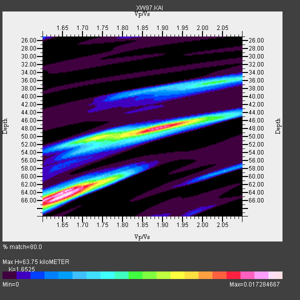
| Thickness Estimate: | 64 km |
| Thickness StdDev: | 7.8 km |
| Vp/Vs Estimate: | 1.65 |
| Vp/Vs StdDev: | 0.12 |
| Vs Estimate: | 3.928 km/s |
| Poisson's Ratio: | 0.21 |
| Peak Value: | 0.02 |
| Assumed Vp: | 6.491 km/s |
| Ps Weight: | 0.33333334 |
| PpPs Weight: | 0.33333334 |
| PsPs Weight: | 0.33333328 |
| Residual Complexity: | 0.799 |
| Nearby stations H: | +- |
| (2.0 deg) Vp/Vs: | +- |
5 with match > 90% ( 41.666668 %) and 12 with match > 80% ( 100.0 %) out of 12.
Download stack as xyz text file.
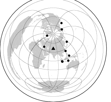
Azimuth Distribution of Events:
Prior Results for this Station
| Study | Thickness | Vp/Vs | Vp | Vs | Poissons Ratio | Extra |
| EARS | 64 km | 1.65 | 6.491 km/s | 3.928 km/s | 0.21 | |
| Crust2.0 | 55 km | 1.76 | 6.491 km/s | 3.696 km/s | 0.26 | R4,orogen/55km Tibet Transition, 0 km seds. |
| Global Maxima | 64 km | 1.65 | 6.491 km/s | 3.928 km/s | 0.21 | amp=0.017284667 |
| Local Maxima 1 | 48 km | 1.89 | 6.491 km/s | 3.434 km/s | 0.31 | amp=0.014894742 |
| Local Maxima 2 | 66 km | 1.62 | 6.491 km/s | 3.994 km/s | 0.20 | amp=0.011402725 |
| Local Maxima 3 | 36 km | 2.04 | 6.491 km/s | 3.19 km/s | 0.34 | amp=0.00795894 |
| Local Maxima 4 | 60 km | 1.76 | 6.491 km/s | 3.678 km/s | 0.26 | amp=0.007598226 |
| Predicted Arrivals for vertical incidence (zero ray parameter) | |
| Ps | 6.41 SECOND |
| PpPs | 26.05 SECOND |
| PsPs/PpSs | 32.46 SECOND |
Events Processed for this Station
Download zip of receiver functions as SAC
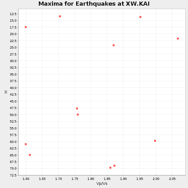
Plot maxima for each earthquake.
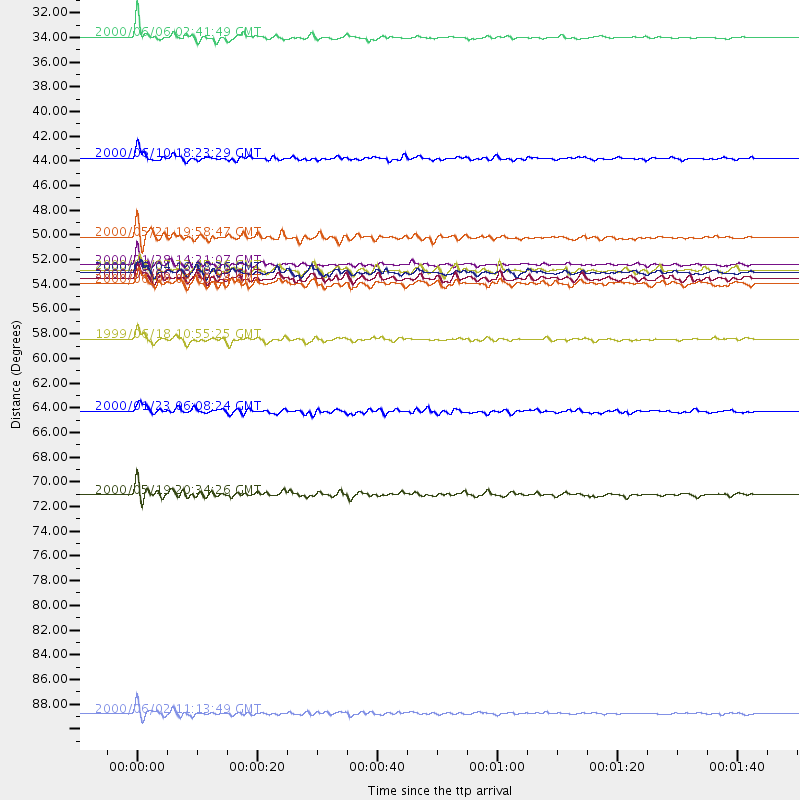
Events Used in the Stack
(12 events)| Radial Match | Distance | Baz | FERegion | Time | Lat/Lon | Depth | Magnitude |
| 93.44406 | 51.6 deg | 62.72 deg | Kuril Islands | 2000/01/28 14:21:07 GMT | (43.0, 146.8) | 61 km | 6.7 MB, 6.6 MS, 6.8 MW, 6.8 ME |
| 91.95441 | 52.3 deg | 145.006 deg | Southern Sumatra, Indonesia | 2000/06/04 16:28:26 GMT | (-4.7, 102.1) | 33 km | 6.8 MB, 8.0 MS, 7.9 MW, 7.7 MW |
| 91.2378 | 31.4 deg | 282.621 deg | Turkey | 2000/06/06 02:41:49 GMT | (40.7, 33.0) | 10 km | 5.5 MB, 6.1 MS, 6.1 MW, 6.0 MW |
| 91.06538 | 91.4 deg | 17.669 deg | Off Coast Of Oregon | 2000/06/02 11:13:49 GMT | (44.5, -130.1) | 10 km | 5.8 MB, 6.0 MS, 6.2 MW, 6.2 MW |
| 90.23124 | 52.1 deg | 145.154 deg | Southern Sumatra, Indonesia | 2000/06/07 23:45:26 GMT | (-4.6, 101.9) | 33 km | 6.1 MB, 6.7 MS, 6.7 MW, 6.5 MW |
| 88.79076 | 58.2 deg | 113.347 deg | Mindanao, Philippines | 1999/06/18 10:55:25 GMT | (5.5, 126.6) | 33 km | 6.1 MB, 6.1 MS, 6.4 MW, 6.4 MW |
| 88.10788 | 72.0 deg | 23.768 deg | Southern Alaska | 2000/05/19 20:34:26 GMT | (59.2, -153.1) | 80 km | 5.6 MB, 5.9 MW, 5.9 MW |
| 87.579414 | 49.2 deg | 334.803 deg | Jan Mayen Island Region | 2000/05/21 19:58:47 GMT | (71.2, -8.3) | 10 km | 5.3 MB, 5.6 MS, 6.0 MW, 6.0 MW |
| 86.40693 | 42.2 deg | 100.055 deg | Taiwan | 2000/06/10 18:23:29 GMT | (23.8, 121.2) | 33 km | 6.2 MB, 6.2 MS, 6.4 MW, 6.3 MW |
| 85.055046 | 53.3 deg | 144.786 deg | Southern Sumatra, Indonesia | 2000/06/09 08:00:24 GMT | (-5.5, 102.7) | 33 km | 5.8 MB, 5.8 MS, 6.0 MW, 6.0 MW |
| 84.54933 | 52.9 deg | 144.516 deg | Southern Sumatra, Indonesia | 2000/06/06 09:58:06 GMT | (-5.1, 102.7) | 33 km | 5.8 MB, 6.1 MS, 6.2 MW, 6.1 MW |
| 81.77132 | 64.6 deg | 128.426 deg | Flores Sea | 2000/01/23 06:08:24 GMT | (-8.0, 120.6) | 47 km | 5.7 MB, 5.2 MS, 5.8 MW, 5.7 MW |
Losers
(0 events)| Radial Match | Distance | Baz | FERegion | Time | Lat/Lon | Depth | Magnitude | Reason |
