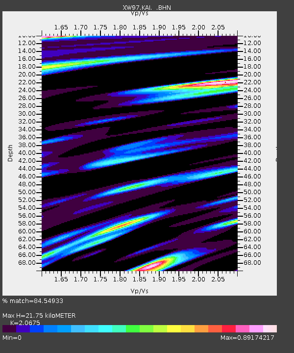
KAI XW.KAI - Earthquake Result Viewer

Earthquake location: Southern Sumatra, Indonesia
Earthquake latitude/longitude: -5.1/102.7
Earthquake time(UTC): 2000/06/06 (158) 09:58:06 GMT
Earthquake Depth: 33 km
Earthquake Magnitude: 5.8 MB, 6.1 MS, 6.2 MW, 6.1 MW
Earthquake Catalog/Contributor: WHDF/NEIC
Network: XW Tien Shan Continental Dynamics
Station: KAI XW.KAI
Lat/Lon: 41.57 N/75.01 E
Elevation: 2016 m
Distance: 52.9 deg
Az: 334.07 deg
Baz: 144.516 deg
Ray Param: 0.06641582
Estimated Moho Depth: 21.75 km
Estimated Crust Vp/Vs: 2.07
Assumed Crust Vp: 6.491 km/s
Estimated Crust Vs: 3.139 km/s
Estimated Crust Poisson's Ratio: 0.35
Radial Match: 84.54933 %
Radial Bump: 400
Transverse Match: 78.53991 %
Transverse Bump: 400
SOD ConfigId: 20082
Insert Time: 2010-02-26 15:24:08.539 +0000
GWidth: 2.5
Max Bumps: 400
Tol: 0.001

Signal To Noise

ChannelStoNSTALTA
XW:KAI: :BHN:20000606T10:06:48.725017Z12.6774256.821755E-75.3810258E-8
XW:KAI: :BHE:20000606T10:06:48.725017Z12.2984053.9974515E-73.250382E-8
XW:KAI: :BHZ:20000606T10:06:48.725017Z31.9335941.9163178E-66.000946E-8
Arrivals
Ps3.8 SECOND
PpPs9.8 SECOND
PsPs/PpSs14 SECOND