You are here: Home > Network List > XW97 - Tien Shan Continental Dynamics Stations List
> Station KAI XW.KAI > Earthquake Result Viewer
KAI XW.KAI - Earthquake Result Viewer
| Earthquake location: |
Southern Alaska |
| Earthquake latitude/longitude: |
59.2/-153.1 |
| Earthquake time(UTC): |
2000/05/19 (140) 20:34:26 GMT |
| Earthquake Depth: |
80 km |
| Earthquake Magnitude: |
5.6 MB, 5.9 MW, 5.9 MW |
| Earthquake Catalog/Contributor: |
WHDF/NEIC |
|
| Network: |
XW Tien Shan Continental Dynamics |
| Station: |
KAI XW.KAI |
| Lat/Lon: |
41.57 N/75.01 E |
| Elevation: |
2016 m |
|
| Distance: |
72.0 deg |
| Az: |
324.0 deg |
| Baz: |
23.768 deg |
| Ray Param: |
0.053776335 |
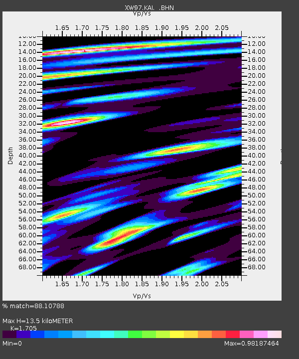
| Estimated Moho Depth: |
13.5 km |
| Estimated Crust Vp/Vs: |
1.71 |
| Assumed Crust Vp: |
6.491 km/s |
| Estimated Crust Vs: |
3.807 km/s |
| Estimated Crust Poisson's Ratio: |
0.24 |
|
| Radial Match: |
88.10788 % |
| Radial Bump: |
346 |
| Transverse Match: |
75.31068 % |
| Transverse Bump: |
400 |
| SOD ConfigId: |
20082 |
| Insert Time: |
2010-02-26 15:24:15.444 +0000 |
| GWidth: |
2.5 |
| Max Bumps: |
400 |
| Tol: |
0.001 |
|

Signal To Noise
| Channel | StoN | STA | LTA |
| XW:KAI: :BHN:20000519T20:45:10.282004Z | 5.2900524 | 3.1253774E-7 | 5.908027E-8 |
| XW:KAI: :BHE:20000519T20:45:10.282004Z | 1.5852298 | 5.82219E-8 | 3.6727734E-8 |
| XW:KAI: :BHZ:20000519T20:45:10.282004Z | 11.52003 | 4.594388E-7 | 3.9881737E-8 |
| Arrivals |
| Ps | 1.5 SECOND |
| PpPs | 5.4 SECOND |
| PsPs/PpSs | 6.9 SECOND |


