You are here: Home > Network List > GE - GEOFON Stations List
> Station RUE GRSN/GEOFON Station Ruedersdorf, Germany > Earthquake Result Viewer
RUE GRSN/GEOFON Station Ruedersdorf, Germany - Earthquake Result Viewer
| Earthquake location: |
Near East Coast Of Kamchatka |
| Earthquake latitude/longitude: |
55.6/161.7 |
| Earthquake time(UTC): |
2006/08/17 (229) 11:11:35 GMT |
| Earthquake Depth: |
55 km |
| Earthquake Magnitude: |
6.1 MB, 5.7 MW, 5.7 MW |
| Earthquake Catalog/Contributor: |
WHDF/NEIC |
|
| Network: |
GE GEOFON |
| Station: |
RUE GRSN/GEOFON Station Ruedersdorf, Germany |
| Lat/Lon: |
52.48 N/13.78 E |
| Elevation: |
40 m |
|
| Distance: |
69.1 deg |
| Az: |
339.636 deg |
| Baz: |
18.829 deg |
| Ray Param: |
0.055786796 |
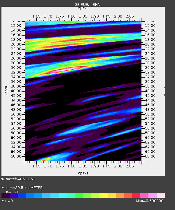
| Estimated Moho Depth: |
30.5 km |
| Estimated Crust Vp/Vs: |
1.78 |
| Assumed Crust Vp: |
6.039 km/s |
| Estimated Crust Vs: |
3.393 km/s |
| Estimated Crust Poisson's Ratio: |
0.27 |
|
| Radial Match: |
86.1052 % |
| Radial Bump: |
400 |
| Transverse Match: |
70.53039 % |
| Transverse Bump: |
400 |
| SOD ConfigId: |
2564 |
| Insert Time: |
2010-03-09 06:16:14.683 +0000 |
| GWidth: |
2.5 |
| Max Bumps: |
400 |
| Tol: |
0.001 |
|

Signal To Noise
| Channel | StoN | STA | LTA |
| GE:RUE: :BHN:20060817T11:22:04.670005Z | 3.6070058 | 6.0591583E-7 | 1.6798305E-7 |
| GE:RUE: :BHE:20060817T11:22:04.670005Z | 1.7346756 | 2.931657E-7 | 1.6900317E-7 |
| GE:RUE: :BHZ:20060817T11:22:04.670005Z | 10.15425 | 1.5155362E-6 | 1.492514E-7 |
| Arrivals |
| Ps | 4.1 SECOND |
| PpPs | 14 SECOND |
| PsPs/PpSs | 18 SECOND |


