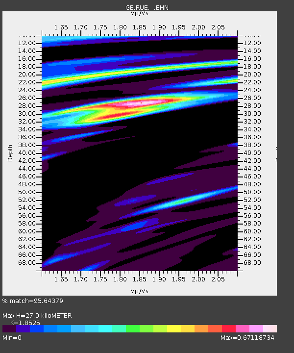
RUE GRSN/GEOFON Station Ruedersdorf, Germany - Earthquake Result Viewer

Earthquake location: Northern Sumatra, Indonesia
Earthquake latitude/longitude: 2.4/96.3
Earthquake time(UTC): 2006/08/11 (223) 20:54:14 GMT
Earthquake Depth: 22 km
Earthquake Magnitude: 5.8 MB, 6.2 MS, 6.2 MW, 6.1 MW
Earthquake Catalog/Contributor: WHDF/NEIC
Network: GE GEOFON
Station: RUE GRSN/GEOFON Station Ruedersdorf, Germany
Lat/Lon: 52.48 N/13.78 E
Elevation: 40 m
Distance: 83.6 deg
Az: 322.384 deg
Baz: 94.431 deg
Ray Param: 0.046072748
Estimated Moho Depth: 27.0 km
Estimated Crust Vp/Vs: 1.85
Assumed Crust Vp: 6.039 km/s
Estimated Crust Vs: 3.26 km/s
Estimated Crust Poisson's Ratio: 0.29
Radial Match: 95.64379 %
Radial Bump: 400
Transverse Match: 76.49943 %
Transverse Bump: 400
SOD ConfigId: 2665
Insert Time: 2010-03-09 06:16:23.966 +0000
GWidth: 2.5
Max Bumps: 400
Tol: 0.001

Signal To Noise

ChannelStoNSTALTA
GE:RUE: :BHN:20060811T21:06:09.320012Z1.07609629.332257E-88.672326E-8
GE:RUE: :BHE:20060811T21:06:09.320012Z4.1232293.002084E-77.280906E-8
GE:RUE: :BHZ:20060811T21:06:09.320012Z9.3504738.456306E-79.04372E-8
Arrivals
Ps3.9 SECOND
PpPs12 SECOND
PsPs/PpSs16 SECOND