You are here: Home > Network List > GE - GEOFON Stations List
> Station RUE GRSN/GEOFON Station Ruedersdorf, Germany > Earthquake Result Viewer
RUE GRSN/GEOFON Station Ruedersdorf, Germany - Earthquake Result Viewer
| Earthquake location: |
Tajikistan |
| Earthquake latitude/longitude: |
39.1/71.8 |
| Earthquake time(UTC): |
2006/07/06 (187) 03:57:53 GMT |
| Earthquake Depth: |
24 km |
| Earthquake Magnitude: |
5.6 MB, 5.7 MS, 5.7 MW, 5.7 MW |
| Earthquake Catalog/Contributor: |
WHDF/NEIC |
|
| Network: |
GE GEOFON |
| Station: |
RUE GRSN/GEOFON Station Ruedersdorf, Germany |
| Lat/Lon: |
52.48 N/13.78 E |
| Elevation: |
40 m |
|
| Distance: |
41.5 deg |
| Az: |
308.432 deg |
| Baz: |
84.906 deg |
| Ray Param: |
0.073718615 |
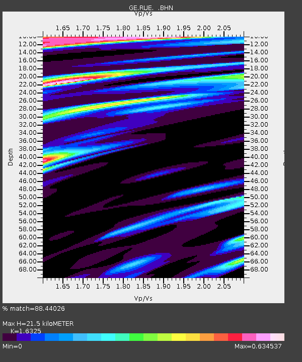
| Estimated Moho Depth: |
21.5 km |
| Estimated Crust Vp/Vs: |
1.63 |
| Assumed Crust Vp: |
6.039 km/s |
| Estimated Crust Vs: |
3.699 km/s |
| Estimated Crust Poisson's Ratio: |
0.20 |
|
| Radial Match: |
88.44026 % |
| Radial Bump: |
359 |
| Transverse Match: |
62.956203 % |
| Transverse Bump: |
400 |
| SOD ConfigId: |
2665 |
| Insert Time: |
2010-03-09 06:16:28.854 +0000 |
| GWidth: |
2.5 |
| Max Bumps: |
400 |
| Tol: |
0.001 |
|

Signal To Noise
| Channel | StoN | STA | LTA |
| GE:RUE: :BHN:20060706T04:05:07.771005Z | 1.3410184 | 2.0210436E-7 | 1.5070961E-7 |
| GE:RUE: :BHE:20060706T04:05:07.771005Z | 3.2459736 | 4.720922E-7 | 1.4543933E-7 |
| GE:RUE: :BHZ:20060706T04:05:07.771005Z | 6.412998 | 9.1816963E-7 | 1.4317322E-7 |
| Arrivals |
| Ps | 2.4 SECOND |
| PpPs | 8.8 SECOND |
| PsPs/PpSs | 11 SECOND |


