You are here: Home > Network List > GE - GEOFON Stations List
> Station RUE GRSN/GEOFON Station Ruedersdorf, Germany > Earthquake Result Viewer
RUE GRSN/GEOFON Station Ruedersdorf, Germany - Earthquake Result Viewer
| Earthquake location: |
Kamchatka Peninsula, Russia |
| Earthquake latitude/longitude: |
54.3/158.4 |
| Earthquake time(UTC): |
2006/05/22 (142) 13:08:01 GMT |
| Earthquake Depth: |
185 km |
| Earthquake Magnitude: |
6.2 MB, 6.2 MW, 6.2 MW |
| Earthquake Catalog/Contributor: |
WHDF/NEIC |
|
| Network: |
GE GEOFON |
| Station: |
RUE GRSN/GEOFON Station Ruedersdorf, Germany |
| Lat/Lon: |
52.48 N/13.78 E |
| Elevation: |
40 m |
|
| Distance: |
69.6 deg |
| Az: |
337.819 deg |
| Baz: |
21.221 deg |
| Ray Param: |
0.05500885 |
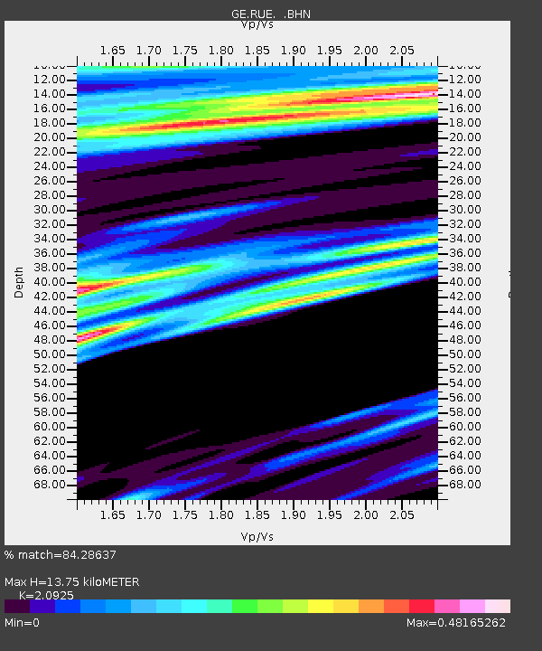
| Estimated Moho Depth: |
13.75 km |
| Estimated Crust Vp/Vs: |
2.09 |
| Assumed Crust Vp: |
6.039 km/s |
| Estimated Crust Vs: |
2.886 km/s |
| Estimated Crust Poisson's Ratio: |
0.35 |
|
| Radial Match: |
84.28637 % |
| Radial Bump: |
400 |
| Transverse Match: |
65.03994 % |
| Transverse Bump: |
400 |
| SOD ConfigId: |
2669 |
| Insert Time: |
2010-03-09 06:16:33.694 +0000 |
| GWidth: |
2.5 |
| Max Bumps: |
400 |
| Tol: |
0.001 |
|

Signal To Noise
| Channel | StoN | STA | LTA |
| GE:RUE: :BHN:20060522T13:18:19.971025Z | 4.8395166 | 2.1884032E-6 | 4.521946E-7 |
| GE:RUE: :BHE:20060522T13:18:19.971025Z | 2.7387493 | 9.317764E-7 | 3.4021969E-7 |
| GE:RUE: :BHZ:20060522T13:18:19.971025Z | 20.55176 | 6.6086345E-6 | 3.2156052E-7 |
| Arrivals |
| Ps | 2.6 SECOND |
| PpPs | 6.9 SECOND |
| PsPs/PpSs | 9.4 SECOND |


