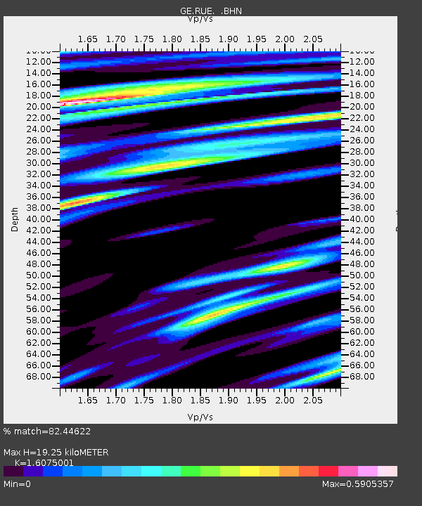
RUE GRSN/GEOFON Station Ruedersdorf, Germany - Earthquake Result Viewer

Earthquake location: Northern Sumatra, Indonesia
Earthquake latitude/longitude: 5.5/94.4
Earthquake time(UTC): 2006/05/13 (133) 03:11:42 GMT
Earthquake Depth: 46 km
Earthquake Magnitude: 5.9 MB, 4.9 MS, 5.7 MW, 5.6 MW
Earthquake Catalog/Contributor: WHDF/NEIC
Network: GE GEOFON
Station: RUE GRSN/GEOFON Station Ruedersdorf, Germany
Lat/Lon: 52.48 N/13.78 E
Elevation: 40 m
Distance: 80.0 deg
Az: 322.198 deg
Baz: 94.046 deg
Ray Param: 0.04852611
Estimated Moho Depth: 19.25 km
Estimated Crust Vp/Vs: 1.61
Assumed Crust Vp: 6.039 km/s
Estimated Crust Vs: 3.757 km/s
Estimated Crust Poisson's Ratio: 0.18
Radial Match: 82.44622 %
Radial Bump: 400
Transverse Match: 61.816975 %
Transverse Bump: 400
SOD ConfigId: 2669
Insert Time: 2010-03-09 06:16:36.197 +0000
GWidth: 2.5
Max Bumps: 400
Tol: 0.001

Signal To Noise

ChannelStoNSTALTA
GE:RUE: :BHN:20060513T03:23:16.221006Z1.35682821.4278777E-71.05236445E-7
GE:RUE: :BHE:20060513T03:23:16.221006Z4.3085783.503715E-78.131953E-8
GE:RUE: :BHZ:20060513T03:23:16.221006Z14.2969151.2548552E-68.777104E-8
Arrivals
Ps2.0 SECOND
PpPs8.1 SECOND
PsPs/PpSs10 SECOND