You are here: Home > Network List > GE - GEOFON Stations List
> Station RUE GRSN/GEOFON Station Ruedersdorf, Germany > Earthquake Result Viewer
RUE GRSN/GEOFON Station Ruedersdorf, Germany - Earthquake Result Viewer
| Earthquake location: |
Myanmar-India Border Region |
| Earthquake latitude/longitude: |
23.3/94.3 |
| Earthquake time(UTC): |
2006/05/11 (131) 17:22:54 GMT |
| Earthquake Depth: |
48 km |
| Earthquake Magnitude: |
5.7 MB, 5.4 MS, 5.4 MW |
| Earthquake Catalog/Contributor: |
WHDF/NEIC |
|
| Network: |
GE GEOFON |
| Station: |
RUE GRSN/GEOFON Station Ruedersdorf, Germany |
| Lat/Lon: |
52.48 N/13.78 E |
| Elevation: |
40 m |
|
| Distance: |
66.2 deg |
| Az: |
318.74 deg |
| Baz: |
82.389 deg |
| Ray Param: |
0.05767874 |
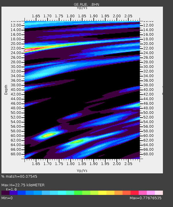
| Estimated Moho Depth: |
22.75 km |
| Estimated Crust Vp/Vs: |
1.60 |
| Assumed Crust Vp: |
6.039 km/s |
| Estimated Crust Vs: |
3.774 km/s |
| Estimated Crust Poisson's Ratio: |
0.18 |
|
| Radial Match: |
80.07545 % |
| Radial Bump: |
400 |
| Transverse Match: |
66.107 % |
| Transverse Bump: |
400 |
| SOD ConfigId: |
2669 |
| Insert Time: |
2010-03-09 06:16:37.478 +0000 |
| GWidth: |
2.5 |
| Max Bumps: |
400 |
| Tol: |
0.001 |
|

Signal To Noise
| Channel | StoN | STA | LTA |
| GE:RUE: :BHN:20060511T17:33:06.020005Z | 1.7392588 | 1.6703433E-7 | 9.6037645E-8 |
| GE:RUE: :BHE:20060511T17:33:06.020005Z | 2.913327 | 2.778103E-7 | 9.535843E-8 |
| GE:RUE: :BHZ:20060511T17:33:06.020005Z | 7.703264 | 7.7696944E-7 | 1.00862366E-7 |
| Arrivals |
| Ps | 2.4 SECOND |
| PpPs | 9.4 SECOND |
| PsPs/PpSs | 12 SECOND |


