You are here: Home > Network List > GE - GEOFON Stations List
> Station RUE GRSN/GEOFON Station Ruedersdorf, Germany > Earthquake Result Viewer
RUE GRSN/GEOFON Station Ruedersdorf, Germany - Earthquake Result Viewer
| Earthquake location: |
Eastern Siberia, Russia |
| Earthquake latitude/longitude: |
60.5/165.8 |
| Earthquake time(UTC): |
2006/04/21 (111) 04:32:43 GMT |
| Earthquake Depth: |
9.0 km |
| Earthquake Magnitude: |
6.3 MB, 5.6 MS, 6.1 MW, 6.1 ME |
| Earthquake Catalog/Contributor: |
WHDF/NEIC |
|
| Network: |
GE GEOFON |
| Station: |
RUE GRSN/GEOFON Station Ruedersdorf, Germany |
| Lat/Lon: |
52.48 N/13.78 E |
| Elevation: |
40 m |
|
| Distance: |
65.1 deg |
| Az: |
341.572 deg |
| Baz: |
14.808 deg |
| Ray Param: |
0.0584715 |
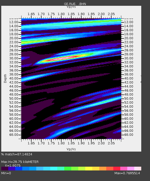
| Estimated Moho Depth: |
29.75 km |
| Estimated Crust Vp/Vs: |
1.81 |
| Assumed Crust Vp: |
6.039 km/s |
| Estimated Crust Vs: |
3.341 km/s |
| Estimated Crust Poisson's Ratio: |
0.28 |
|
| Radial Match: |
87.14824 % |
| Radial Bump: |
400 |
| Transverse Match: |
78.320984 % |
| Transverse Bump: |
400 |
| SOD ConfigId: |
2669 |
| Insert Time: |
2010-03-09 06:16:42.500 +0000 |
| GWidth: |
2.5 |
| Max Bumps: |
400 |
| Tol: |
0.001 |
|

Signal To Noise
| Channel | StoN | STA | LTA |
| GE:RUE: :BHN:20060421T04:42:53.767998Z | 4.4176426 | 6.0703314E-7 | 1.374111E-7 |
| GE:RUE: :BHE:20060421T04:42:53.767998Z | 1.779605 | 2.228517E-7 | 1.2522537E-7 |
| GE:RUE: :BHZ:20060421T04:42:53.767998Z | 12.218852 | 1.8062821E-6 | 1.4782748E-7 |
| Arrivals |
| Ps | 4.1 SECOND |
| PpPs | 13 SECOND |
| PsPs/PpSs | 17 SECOND |


