You are here: Home > Network List > GE - GEOFON Stations List
> Station RUE GRSN/GEOFON Station Ruedersdorf, Germany > Earthquake Result Viewer
RUE GRSN/GEOFON Station Ruedersdorf, Germany - Earthquake Result Viewer
| Earthquake location: |
Sunda Strait, Indonesia |
| Earthquake latitude/longitude: |
-6.5/105.6 |
| Earthquake time(UTC): |
2000/10/25 (299) 09:32:23 GMT |
| Earthquake Depth: |
38 km |
| Earthquake Magnitude: |
6.3 MB, 6.6 MS, 6.8 MW, 6.7 ME |
| Earthquake Catalog/Contributor: |
WHDF/NEIC |
|
| Network: |
GE GEOFON |
| Station: |
RUE GRSN/GEOFON Station Ruedersdorf, Germany |
| Lat/Lon: |
52.48 N/13.78 E |
| Elevation: |
40 m |
|
| Distance: |
96.3 deg |
| Az: |
322.046 deg |
| Baz: |
92.533 deg |
| Ray Param: |
0.04054262 |
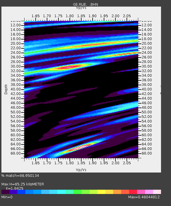
| Estimated Moho Depth: |
65.25 km |
| Estimated Crust Vp/Vs: |
1.84 |
| Assumed Crust Vp: |
6.039 km/s |
| Estimated Crust Vs: |
3.277 km/s |
| Estimated Crust Poisson's Ratio: |
0.29 |
|
| Radial Match: |
86.950134 % |
| Radial Bump: |
400 |
| Transverse Match: |
78.53569 % |
| Transverse Bump: |
400 |
| SOD ConfigId: |
3744 |
| Insert Time: |
2010-03-09 06:16:50.151 +0000 |
| GWidth: |
2.5 |
| Max Bumps: |
400 |
| Tol: |
0.001 |
|

Signal To Noise
| Channel | StoN | STA | LTA |
| GE:RUE: :BHN:20001025T09:45:16.99002Z | 0.7778241 | 2.1382871E-7 | 2.7490626E-7 |
| GE:RUE: :BHE:20001025T09:45:16.99002Z | 0.8606899 | 2.2747736E-7 | 2.6429652E-7 |
| GE:RUE: :BHZ:20001025T09:45:16.99002Z | 3.4110742 | 8.226136E-7 | 2.4115968E-7 |
| Arrivals |
| Ps | 9.3 SECOND |
| PpPs | 30 SECOND |
| PsPs/PpSs | 39 SECOND |


