You are here: Home > Network List > GE - GEOFON Stations List
> Station RUE GRSN/GEOFON Station Ruedersdorf, Germany > Earthquake Result Viewer
RUE GRSN/GEOFON Station Ruedersdorf, Germany - Earthquake Result Viewer
| Earthquake location: |
Hindu Kush Region, Afghanistan |
| Earthquake latitude/longitude: |
36.3/70.9 |
| Earthquake time(UTC): |
2000/07/17 (199) 22:53:47 GMT |
| Earthquake Depth: |
141 km |
| Earthquake Magnitude: |
6.0 MB, 6.4 MW, 6.3 MW |
| Earthquake Catalog/Contributor: |
WHDF/NEIC |
|
| Network: |
GE GEOFON |
| Station: |
RUE GRSN/GEOFON Station Ruedersdorf, Germany |
| Lat/Lon: |
52.48 N/13.78 E |
| Elevation: |
40 m |
|
| Distance: |
42.8 deg |
| Az: |
310.811 deg |
| Baz: |
88.853 deg |
| Ray Param: |
0.07245892 |
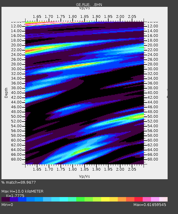
| Estimated Moho Depth: |
10.0 km |
| Estimated Crust Vp/Vs: |
1.78 |
| Assumed Crust Vp: |
6.039 km/s |
| Estimated Crust Vs: |
3.397 km/s |
| Estimated Crust Poisson's Ratio: |
0.27 |
|
| Radial Match: |
89.9677 % |
| Radial Bump: |
289 |
| Transverse Match: |
73.79799 % |
| Transverse Bump: |
400 |
| SOD ConfigId: |
3744 |
| Insert Time: |
2010-03-09 06:16:54.300 +0000 |
| GWidth: |
2.5 |
| Max Bumps: |
400 |
| Tol: |
0.001 |
|

Signal To Noise
| Channel | StoN | STA | LTA |
| GE:RUE: :BHN:20000717T23:01:00.215009Z | 1.9074885 | 2.2263836E-7 | 1.1671806E-7 |
| GE:RUE: :BHE:20000717T23:01:00.215009Z | 20.68178 | 1.9413958E-6 | 9.3869865E-8 |
| GE:RUE: :BHZ:20000717T23:01:00.215009Z | 40.271145 | 3.6939653E-6 | 9.1727344E-8 |
| Arrivals |
| Ps | 1.4 SECOND |
| PpPs | 4.3 SECOND |
| PsPs/PpSs | 5.7 SECOND |


