You are here: Home > Network List > GE - GEOFON Stations List
> Station RUE GRSN/GEOFON Station Ruedersdorf, Germany > Earthquake Result Viewer
RUE GRSN/GEOFON Station Ruedersdorf, Germany - Earthquake Result Viewer
| Earthquake location: |
Colombia |
| Earthquake latitude/longitude: |
3.9/-76.0 |
| Earthquake time(UTC): |
2001/09/22 (265) 03:23:38 GMT |
| Earthquake Depth: |
179 km |
| Earthquake Magnitude: |
6.0 MB, 6.0 MW, 6.0 MW |
| Earthquake Catalog/Contributor: |
WHDF/NEIC |
|
| Network: |
GE GEOFON |
| Station: |
RUE GRSN/GEOFON Station Ruedersdorf, Germany |
| Lat/Lon: |
52.48 N/13.78 E |
| Elevation: |
40 m |
|
| Distance: |
86.8 deg |
| Az: |
37.779 deg |
| Baz: |
272.156 deg |
| Ray Param: |
0.04337407 |
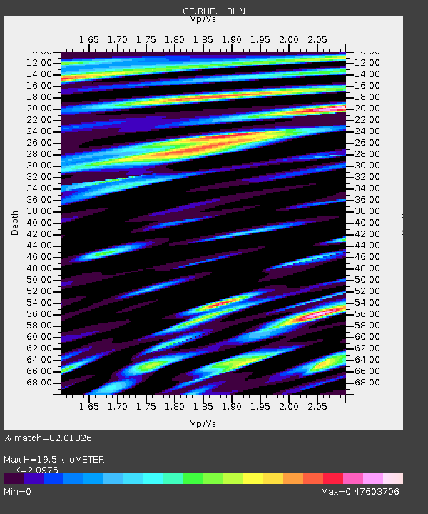
| Estimated Moho Depth: |
19.5 km |
| Estimated Crust Vp/Vs: |
2.10 |
| Assumed Crust Vp: |
6.039 km/s |
| Estimated Crust Vs: |
2.879 km/s |
| Estimated Crust Poisson's Ratio: |
0.35 |
|
| Radial Match: |
82.01326 % |
| Radial Bump: |
400 |
| Transverse Match: |
77.660484 % |
| Transverse Bump: |
400 |
| SOD ConfigId: |
20082 |
| Insert Time: |
2010-03-09 06:17:31.246 +0000 |
| GWidth: |
2.5 |
| Max Bumps: |
400 |
| Tol: |
0.001 |
|

Signal To Noise
| Channel | StoN | STA | LTA |
| GE:RUE: :BHN:20010922T03:35:31.102019Z | 1.9240985 | 1.7670894E-7 | 9.1839865E-8 |
| GE:RUE: :BHE:20010922T03:35:31.102019Z | 4.1244116 | 3.393287E-7 | 8.227324E-8 |
| GE:RUE: :BHZ:20010922T03:35:31.102019Z | 21.10101 | 1.7194689E-6 | 8.1487514E-8 |
| Arrivals |
| Ps | 3.6 SECOND |
| PpPs | 9.8 SECOND |
| PsPs/PpSs | 13 SECOND |


