You are here: Home > Network List > GE - GEOFON Stations List
> Station RUE GRSN/GEOFON Station Ruedersdorf, Germany > Earthquake Result Viewer
RUE GRSN/GEOFON Station Ruedersdorf, Germany - Earthquake Result Viewer
| Earthquake location: |
Hindu Kush Region, Afghanistan |
| Earthquake latitude/longitude: |
36.4/70.9 |
| Earthquake time(UTC): |
2001/02/25 (056) 02:21:59 GMT |
| Earthquake Depth: |
202 km |
| Earthquake Magnitude: |
5.8 MB, 6.3 MW, 6.1 MW |
| Earthquake Catalog/Contributor: |
WHDF/NEIC |
|
| Network: |
GE GEOFON |
| Station: |
RUE GRSN/GEOFON Station Ruedersdorf, Germany |
| Lat/Lon: |
52.48 N/13.78 E |
| Elevation: |
40 m |
|
| Distance: |
42.6 deg |
| Az: |
310.695 deg |
| Baz: |
88.729 deg |
| Ray Param: |
0.07225502 |
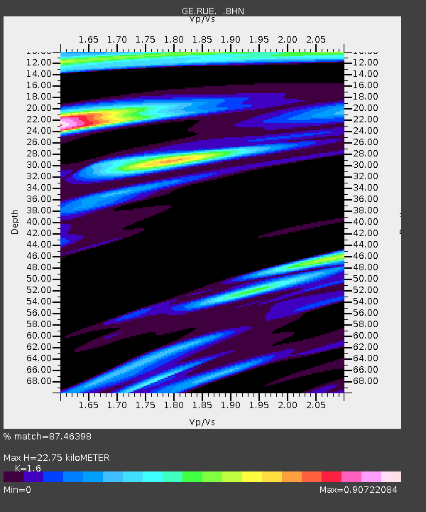
| Estimated Moho Depth: |
22.75 km |
| Estimated Crust Vp/Vs: |
1.60 |
| Assumed Crust Vp: |
6.039 km/s |
| Estimated Crust Vs: |
3.774 km/s |
| Estimated Crust Poisson's Ratio: |
0.18 |
|
| Radial Match: |
87.46398 % |
| Radial Bump: |
400 |
| Transverse Match: |
66.55194 % |
| Transverse Bump: |
400 |
| SOD ConfigId: |
3744 |
| Insert Time: |
2010-03-09 06:17:38.648 +0000 |
| GWidth: |
2.5 |
| Max Bumps: |
400 |
| Tol: |
0.001 |
|

Signal To Noise
| Channel | StoN | STA | LTA |
| GE:RUE: :BHN:20010225T02:29:05.43201Z | 2.1744494 | 3.929302E-7 | 1.807033E-7 |
| GE:RUE: :BHE:20010225T02:29:05.43201Z | 7.2637143 | 1.4632211E-6 | 2.0144255E-7 |
| GE:RUE: :BHZ:20010225T02:29:05.43201Z | 18.067719 | 3.4236127E-6 | 1.8948782E-7 |
| Arrivals |
| Ps | 2.4 SECOND |
| PpPs | 9.2 SECOND |
| PsPs/PpSs | 12 SECOND |


