You are here: Home > Network List > GE - GEOFON Stations List
> Station RUE GRSN/GEOFON Station Ruedersdorf, Germany > Earthquake Result Viewer
RUE GRSN/GEOFON Station Ruedersdorf, Germany - Earthquake Result Viewer
| Earthquake location: |
Hokkaido, Japan Region |
| Earthquake latitude/longitude: |
43.1/145.9 |
| Earthquake time(UTC): |
2001/04/26 (116) 17:48:57 GMT |
| Earthquake Depth: |
86 km |
| Earthquake Magnitude: |
5.7 MB, 6.0 MW, 6.0 MW |
| Earthquake Catalog/Contributor: |
WHDF/NEIC |
|
| Network: |
GE GEOFON |
| Station: |
RUE GRSN/GEOFON Station Ruedersdorf, Germany |
| Lat/Lon: |
52.48 N/13.78 E |
| Elevation: |
40 m |
|
| Distance: |
76.2 deg |
| Az: |
332.164 deg |
| Baz: |
33.999 deg |
| Ray Param: |
0.05093901 |
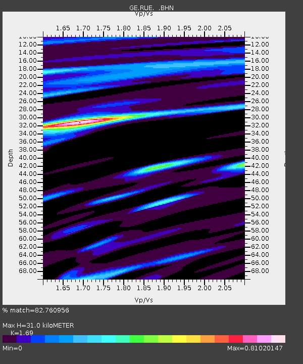
| Estimated Moho Depth: |
31.0 km |
| Estimated Crust Vp/Vs: |
1.69 |
| Assumed Crust Vp: |
6.039 km/s |
| Estimated Crust Vs: |
3.573 km/s |
| Estimated Crust Poisson's Ratio: |
0.23 |
|
| Radial Match: |
82.760956 % |
| Radial Bump: |
400 |
| Transverse Match: |
60.752987 % |
| Transverse Bump: |
400 |
| SOD ConfigId: |
4714 |
| Insert Time: |
2010-03-09 06:17:41.284 +0000 |
| GWidth: |
2.5 |
| Max Bumps: |
400 |
| Tol: |
0.001 |
|

Signal To Noise
| Channel | StoN | STA | LTA |
| GE:RUE: :BHN:20010426T18:00:05.634001Z | 2.1921678 | 2.2949996E-7 | 1.04690876E-7 |
| GE:RUE: :BHE:20010426T18:00:05.634001Z | 1.4988284 | 1.6786896E-7 | 1.1200012E-7 |
| GE:RUE: :BHZ:20010426T18:00:05.634001Z | 6.938703 | 7.3481095E-7 | 1.05900334E-7 |
| Arrivals |
| Ps | 3.6 SECOND |
| PpPs | 13 SECOND |
| PsPs/PpSs | 17 SECOND |


