You are here: Home > Network List > GE - GEOFON Stations List
> Station RUE GRSN/GEOFON Station Ruedersdorf, Germany > Earthquake Result Viewer
RUE GRSN/GEOFON Station Ruedersdorf, Germany - Earthquake Result Viewer
| Earthquake location: |
Taiwan Region |
| Earthquake latitude/longitude: |
24.1/122.3 |
| Earthquake time(UTC): |
2002/05/28 (148) 16:45:17 GMT |
| Earthquake Depth: |
33 km |
| Earthquake Magnitude: |
5.8 MB, 5.9 MS, 6.0 MW, 6.0 MW |
| Earthquake Catalog/Contributor: |
WHDF/NEIC |
|
| Network: |
GE GEOFON |
| Station: |
RUE GRSN/GEOFON Station Ruedersdorf, Germany |
| Lat/Lon: |
52.48 N/13.78 E |
| Elevation: |
40 m |
|
| Distance: |
81.7 deg |
| Az: |
324.113 deg |
| Baz: |
61.163 deg |
| Ray Param: |
0.04732611 |
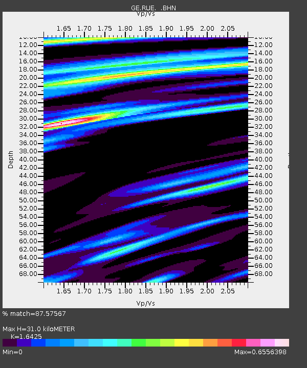
| Estimated Moho Depth: |
31.0 km |
| Estimated Crust Vp/Vs: |
1.64 |
| Assumed Crust Vp: |
6.039 km/s |
| Estimated Crust Vs: |
3.677 km/s |
| Estimated Crust Poisson's Ratio: |
0.21 |
|
| Radial Match: |
87.57567 % |
| Radial Bump: |
400 |
| Transverse Match: |
69.72379 % |
| Transverse Bump: |
342 |
| SOD ConfigId: |
20082 |
| Insert Time: |
2010-03-09 06:17:53.320 +0000 |
| GWidth: |
2.5 |
| Max Bumps: |
400 |
| Tol: |
0.001 |
|

Signal To Noise
| Channel | StoN | STA | LTA |
| GE:RUE: :BHN:20020528T16:57:01.308008Z | 1.4905249 | 2.064443E-7 | 1.3850443E-7 |
| GE:RUE: :BHE:20020528T16:57:01.308008Z | 2.3688457 | 3.2636478E-7 | 1.3777377E-7 |
| GE:RUE: :BHZ:20020528T16:57:01.308008Z | 8.218246 | 1.0960464E-6 | 1.3336744E-7 |
| Arrivals |
| Ps | 3.4 SECOND |
| PpPs | 13 SECOND |
| PsPs/PpSs | 17 SECOND |


