You are here: Home > Network List > GE - GEOFON Stations List
> Station RUE GRSN/GEOFON Station Ruedersdorf, Germany > Earthquake Result Viewer
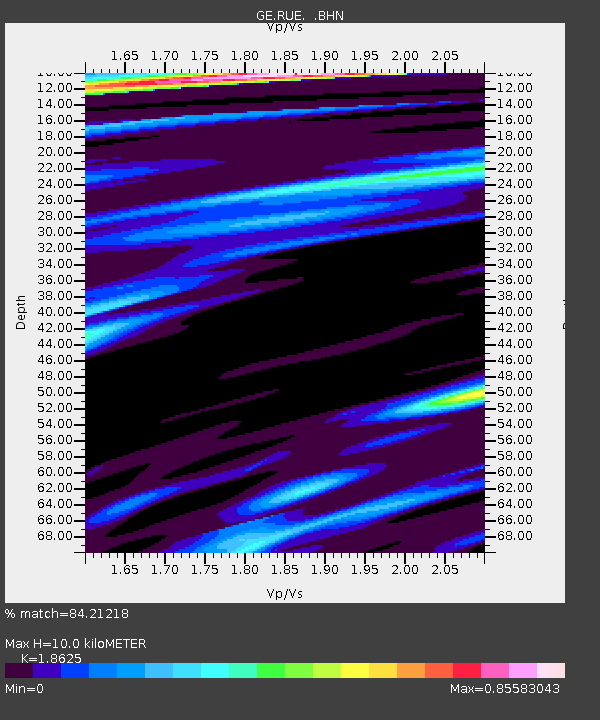
RUE GRSN/GEOFON Station Ruedersdorf, Germany - Earthquake Result Viewer
| Earthquake location: |
Hindu Kush Region, Afghanistan |
| Earthquake latitude/longitude: |
36.1/70.7 |
| Earthquake time(UTC): |
2002/01/03 (003) 07:05:27 GMT |
| Earthquake Depth: |
129 km |
| Earthquake Magnitude: |
5.8 MB, 6.2 MW, 6.1 MW |
| Earthquake Catalog/Contributor: |
WHDF/NEIC |
|
| Network: |
GE GEOFON |
| Station: |
RUE GRSN/GEOFON Station Ruedersdorf, Germany |
| Lat/Lon: |
52.48 N/13.78 E |
| Elevation: |
40 m |
|
| Distance: |
42.7 deg |
| Az: |
310.967 deg |
| Baz: |
89.254 deg |
| Ray Param: |
0.07252344 |
| Estimated Moho Depth: |
10.0 km |
| Estimated Crust Vp/Vs: |
1.86 |
| Assumed Crust Vp: |
6.039 km/s |
| Estimated Crust Vs: |
3.242 km/s |
| Estimated Crust Poisson's Ratio: |
0.30 |
|
| Radial Match: |
84.21218 % |
| Radial Bump: |
357 |
| Transverse Match: |
47.043007 % |
| Transverse Bump: |
288 |
| SOD ConfigId: |
20082 |
| Insert Time: |
2010-03-09 06:18:01.844 +0000 |
| GWidth: |
2.5 |
| Max Bumps: |
400 |
| Tol: |
0.001 |
|

Signal To Noise
| Channel | StoN | STA | LTA |
| GE:RUE: :BHN:20020103T07:12:41.701006Z | 0.9459535 | 3.9479002E-7 | 4.1734612E-7 |
| GE:RUE: :BHE:20020103T07:12:41.701006Z | 3.7708383 | 1.3791181E-6 | 3.657325E-7 |
| GE:RUE: :BHZ:20020103T07:12:41.701006Z | 4.472209 | 2.9644054E-6 | 6.628504E-7 |
| Arrivals |
| Ps | 1.5 SECOND |
| PpPs | 4.5 SECOND |
| PsPs/PpSs | 6.0 SECOND |


