You are here: Home > Network List > GE - GEOFON Stations List
> Station RUE GRSN/GEOFON Station Ruedersdorf, Germany > Earthquake Result Viewer
RUE GRSN/GEOFON Station Ruedersdorf, Germany - Earthquake Result Viewer
| Earthquake location: |
Northeastern China |
| Earthquake latitude/longitude: |
44.8/129.9 |
| Earthquake time(UTC): |
2002/09/15 (258) 08:39:32 GMT |
| Earthquake Depth: |
586 km |
| Earthquake Magnitude: |
5.8 MB, 6.4 MW, 6.4 MW |
| Earthquake Catalog/Contributor: |
WHDF/NEIC |
|
| Network: |
GE GEOFON |
| Station: |
RUE GRSN/GEOFON Station Ruedersdorf, Germany |
| Lat/Lon: |
52.48 N/13.78 E |
| Elevation: |
40 m |
|
| Distance: |
68.6 deg |
| Az: |
323.874 deg |
| Baz: |
43.3 deg |
| Ray Param: |
0.054094475 |
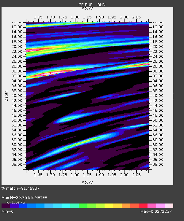
| Estimated Moho Depth: |
30.75 km |
| Estimated Crust Vp/Vs: |
1.70 |
| Assumed Crust Vp: |
6.039 km/s |
| Estimated Crust Vs: |
3.557 km/s |
| Estimated Crust Poisson's Ratio: |
0.23 |
|
| Radial Match: |
91.46337 % |
| Radial Bump: |
400 |
| Transverse Match: |
76.919136 % |
| Transverse Bump: |
400 |
| SOD ConfigId: |
4714 |
| Insert Time: |
2010-03-09 06:18:09.062 +0000 |
| GWidth: |
2.5 |
| Max Bumps: |
400 |
| Tol: |
0.001 |
|

Signal To Noise
| Channel | StoN | STA | LTA |
| GE:RUE: :BHN:20020915T08:49:07.309009Z | 5.3255115 | 8.033377E-7 | 1.5084704E-7 |
| GE:RUE: :BHE:20020915T08:49:07.309009Z | 5.556116 | 6.688696E-7 | 1.2038437E-7 |
| GE:RUE: :BHZ:20020915T08:49:07.309009Z | 27.241873 | 3.246837E-6 | 1.1918552E-7 |
| Arrivals |
| Ps | 3.7 SECOND |
| PpPs | 13 SECOND |
| PsPs/PpSs | 17 SECOND |


