You are here: Home > Network List > GE - GEOFON Stations List
> Station RUE GRSN/GEOFON Station Ruedersdorf, Germany > Earthquake Result Viewer
RUE GRSN/GEOFON Station Ruedersdorf, Germany - Earthquake Result Viewer
| Earthquake location: |
Northwestern Kashmir |
| Earthquake latitude/longitude: |
35.4/74.5 |
| Earthquake time(UTC): |
2002/11/20 (324) 21:32:30 GMT |
| Earthquake Depth: |
33 km |
| Earthquake Magnitude: |
5.7 MB, 6.5 MS, 6.4 MW, 6.0 MW |
| Earthquake Catalog/Contributor: |
WHDF/NEIC |
|
| Network: |
GE GEOFON |
| Station: |
RUE GRSN/GEOFON Station Ruedersdorf, Germany |
| Lat/Lon: |
52.48 N/13.78 E |
| Elevation: |
40 m |
|
| Distance: |
45.5 deg |
| Az: |
311.597 deg |
| Baz: |
87.03 deg |
| Ray Param: |
0.07115472 |
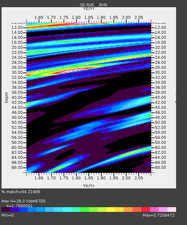
| Estimated Moho Depth: |
29.0 km |
| Estimated Crust Vp/Vs: |
1.79 |
| Assumed Crust Vp: |
6.039 km/s |
| Estimated Crust Vs: |
3.383 km/s |
| Estimated Crust Poisson's Ratio: |
0.27 |
|
| Radial Match: |
84.21688 % |
| Radial Bump: |
391 |
| Transverse Match: |
59.781578 % |
| Transverse Bump: |
356 |
| SOD ConfigId: |
4714 |
| Insert Time: |
2010-03-09 06:18:11.957 +0000 |
| GWidth: |
2.5 |
| Max Bumps: |
400 |
| Tol: |
0.001 |
|

Signal To Noise
| Channel | StoN | STA | LTA |
| GE:RUE: :BHN:20021120T21:40:16.657992Z | 1.4442924 | 4.1922237E-7 | 2.9026143E-7 |
| GE:RUE: :BHE:20021120T21:40:16.657992Z | 1.1385057 | 3.358061E-7 | 2.9495337E-7 |
| GE:RUE: :BHZ:20021120T21:40:16.657992Z | 2.209934 | 7.22837E-7 | 3.2708536E-7 |
| Arrivals |
| Ps | 4.0 SECOND |
| PpPs | 13 SECOND |
| PsPs/PpSs | 17 SECOND |


