You are here: Home > Network List > GE - GEOFON Stations List
> Station RUE GRSN/GEOFON Station Ruedersdorf, Germany > Earthquake Result Viewer
RUE GRSN/GEOFON Station Ruedersdorf, Germany - Earthquake Result Viewer
| Earthquake location: |
Qinghai, China |
| Earthquake latitude/longitude: |
37.5/96.5 |
| Earthquake time(UTC): |
2003/04/17 (107) 00:48:38 GMT |
| Earthquake Depth: |
14 km |
| Earthquake Magnitude: |
6.2 MB, 6.3 MS, 6.4 MW, 6.2 MW |
| Earthquake Catalog/Contributor: |
WHDF/NEIC |
|
| Network: |
GE GEOFON |
| Station: |
RUE GRSN/GEOFON Station Ruedersdorf, Germany |
| Lat/Lon: |
52.48 N/13.78 E |
| Elevation: |
40 m |
|
| Distance: |
57.2 deg |
| Az: |
313.799 deg |
| Baz: |
69.74 deg |
| Ray Param: |
0.063633025 |
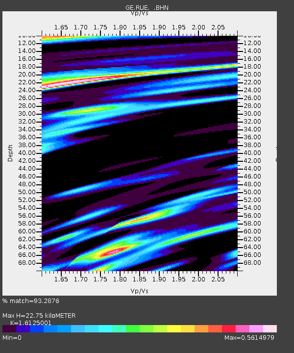
| Estimated Moho Depth: |
22.75 km |
| Estimated Crust Vp/Vs: |
1.61 |
| Assumed Crust Vp: |
6.039 km/s |
| Estimated Crust Vs: |
3.745 km/s |
| Estimated Crust Poisson's Ratio: |
0.19 |
|
| Radial Match: |
93.2876 % |
| Radial Bump: |
400 |
| Transverse Match: |
84.15764 % |
| Transverse Bump: |
400 |
| SOD ConfigId: |
4714 |
| Insert Time: |
2010-03-09 06:18:16.911 +0000 |
| GWidth: |
2.5 |
| Max Bumps: |
400 |
| Tol: |
0.001 |
|

Signal To Noise
| Channel | StoN | STA | LTA |
| GE:RUE: :BHN:20030417T00:57:54.017012Z | 1.5017304 | 2.2246275E-7 | 1.481376E-7 |
| GE:RUE: :BHE:20030417T00:57:54.017012Z | 3.5496964 | 4.436041E-7 | 1.2496959E-7 |
| GE:RUE: :BHZ:20030417T00:57:54.017012Z | 6.308087 | 1.075929E-6 | 1.7056344E-7 |
| Arrivals |
| Ps | 2.4 SECOND |
| PpPs | 9.4 SECOND |
| PsPs/PpSs | 12 SECOND |


