You are here: Home > Network List > GE - GEOFON Stations List
> Station RUE GRSN/GEOFON Station Ruedersdorf, Germany > Earthquake Result Viewer
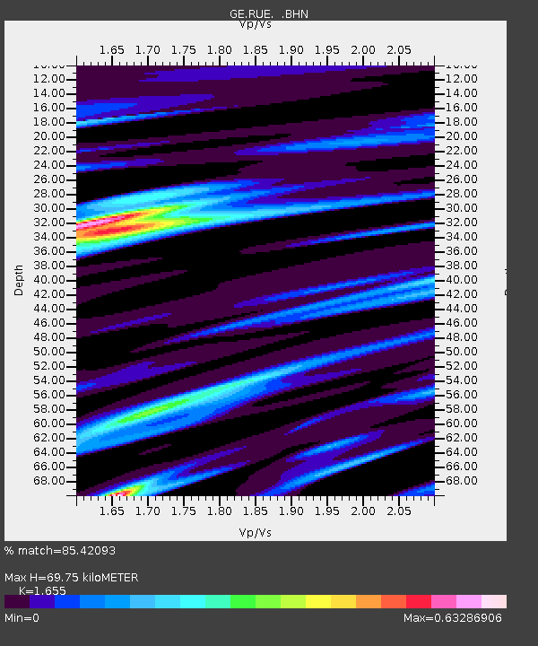
RUE GRSN/GEOFON Station Ruedersdorf, Germany - Earthquake Result Viewer
| Earthquake location: |
Near Coast Of Nicaragua |
| Earthquake latitude/longitude: |
11.4/-86.7 |
| Earthquake time(UTC): |
2004/10/09 (283) 21:26:53 GMT |
| Earthquake Depth: |
35 km |
| Earthquake Magnitude: |
6.0 MB, 7.0 MS, 6.9 MW, 6.8 MW |
| Earthquake Catalog/Contributor: |
WHDF/NEIC |
|
| Network: |
GE GEOFON |
| Station: |
RUE GRSN/GEOFON Station Ruedersdorf, Germany |
| Lat/Lon: |
52.48 N/13.78 E |
| Elevation: |
40 m |
|
| Distance: |
87.3 deg |
| Az: |
37.027 deg |
| Baz: |
285.145 deg |
| Ray Param: |
0.043370795 |
| Estimated Moho Depth: |
69.75 km |
| Estimated Crust Vp/Vs: |
1.65 |
| Assumed Crust Vp: |
6.039 km/s |
| Estimated Crust Vs: |
3.649 km/s |
| Estimated Crust Poisson's Ratio: |
0.21 |
|
| Radial Match: |
85.42093 % |
| Radial Bump: |
400 |
| Transverse Match: |
49.888863 % |
| Transverse Bump: |
400 |
| SOD ConfigId: |
2459 |
| Insert Time: |
2010-03-09 06:18:26.616 +0000 |
| GWidth: |
2.5 |
| Max Bumps: |
400 |
| Tol: |
0.001 |
|

Signal To Noise
| Channel | StoN | STA | LTA |
| GE:RUE: :BHN:20041009T21:39:05.656003Z | 2.191396 | 5.3938027E-7 | 2.4613544E-7 |
| GE:RUE: :BHE:20041009T21:39:05.656003Z | 5.915701 | 9.79416E-7 | 1.6556211E-7 |
| GE:RUE: :BHZ:20041009T21:39:05.656003Z | 10.402009 | 2.3200046E-6 | 2.2303426E-7 |
| Arrivals |
| Ps | 7.7 SECOND |
| PpPs | 30 SECOND |
| PsPs/PpSs | 38 SECOND |


