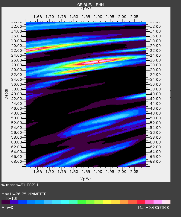
RUE GRSN/GEOFON Station Ruedersdorf, Germany - Earthquake Result Viewer

Earthquake location: Off W Coast Of Northern Sumatra
Earthquake latitude/longitude: 3.0/95.4
Earthquake time(UTC): 2005/03/30 (089) 16:19:41 GMT
Earthquake Depth: 22 km
Earthquake Magnitude: 5.9 MB, 6.2 MS, 6.4 MW, 6.3 MW
Earthquake Catalog/Contributor: WHDF/NEIC
Network: GE GEOFON
Station: RUE GRSN/GEOFON Station Ruedersdorf, Germany
Lat/Lon: 52.48 N/13.78 E
Elevation: 40 m
Distance: 82.5 deg
Az: 322.387 deg
Baz: 94.815 deg
Ray Param: 0.04679775
Estimated Moho Depth: 26.25 km
Estimated Crust Vp/Vs: 1.90
Assumed Crust Vp: 6.039 km/s
Estimated Crust Vs: 3.178 km/s
Estimated Crust Poisson's Ratio: 0.31
Radial Match: 91.00211 %
Radial Bump: 400
Transverse Match: 69.968414 %
Transverse Bump: 400
SOD ConfigId: 2459
Insert Time: 2010-03-09 06:19:05.462 +0000
GWidth: 2.5
Max Bumps: 400
Tol: 0.001

Signal To Noise

ChannelStoNSTALTA
GE:RUE: :BHN:20050330T16:31:30.732019Z0.80761961.7564737E-72.1748775E-7
GE:RUE: :BHE:20050330T16:31:30.732019Z2.39886122.990077E-71.2464568E-7
GE:RUE: :BHZ:20050330T16:31:30.732019Z8.5735981.144901E-61.3353801E-7
Arrivals
Ps4.0 SECOND
PpPs12 SECOND
PsPs/PpSs16 SECOND