You are here: Home > Network List > GE - GEOFON Stations List
> Station SKD GEOFON Station Skordalos, Greece > Earthquake Result Viewer
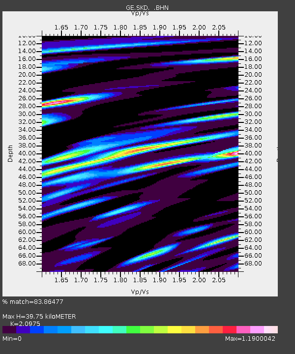
SKD GEOFON Station Skordalos, Greece - Earthquake Result Viewer
| Earthquake location: |
North Atlantic Ocean |
| Earthquake latitude/longitude: |
52.7/-33.7 |
| Earthquake time(UTC): |
1998/02/16 (047) 23:53:19 GMT |
| Earthquake Depth: |
10 km |
| Earthquake Magnitude: |
6.1 MB, 6.6 MS, 6.8 UNKNOWN, 6.8 ME |
| Earthquake Catalog/Contributor: |
WHDF/NEIC |
|
| Network: |
GE GEOFON |
| Station: |
SKD GEOFON Station Skordalos, Greece |
| Lat/Lon: |
35.41 N/23.93 E |
| Elevation: |
306 m |
|
| Distance: |
43.6 deg |
| Az: |
89.703 deg |
| Baz: |
311.866 deg |
| Ray Param: |
0.072442256 |
| Estimated Moho Depth: |
39.75 km |
| Estimated Crust Vp/Vs: |
2.10 |
| Assumed Crust Vp: |
5.55 km/s |
| Estimated Crust Vs: |
2.646 km/s |
| Estimated Crust Poisson's Ratio: |
0.35 |
|
| Radial Match: |
83.86477 % |
| Radial Bump: |
400 |
| Transverse Match: |
74.77593 % |
| Transverse Bump: |
400 |
| SOD ConfigId: |
6273 |
| Insert Time: |
2010-03-09 06:20:18.089 +0000 |
| GWidth: |
2.5 |
| Max Bumps: |
400 |
| Tol: |
0.001 |
|

Signal To Noise
| Channel | StoN | STA | LTA |
| GE:SKD: :BHN:19980217T00:00:53.163013Z | 3.7417812 | 4.36204E-7 | 1.16576565E-7 |
| GE:SKD: :BHE:19980217T00:00:53.163013Z | 3.0740204 | 3.445814E-7 | 1.120947E-7 |
| GE:SKD: :BHZ:19980217T00:00:53.163013Z | 8.975639 | 9.1802576E-7 | 1.0227971E-7 |
| Arrivals |
| Ps | 8.2 SECOND |
| PpPs | 21 SECOND |
| PsPs/PpSs | 29 SECOND |


