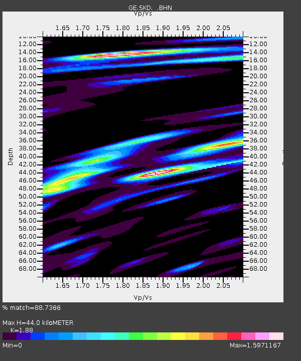
SKD GEOFON Station Skordalos, Greece - Earthquake Result Viewer

Earthquake location: Philippine Islands Region
Earthquake latitude/longitude: 20.3/122.0
Earthquake time(UTC): 2000/07/16 (198) 03:21:45 GMT
Earthquake Depth: 33 km
Earthquake Magnitude: 6.1 MB, 6.3 MS, 6.4 MW, 6.4 MW
Earthquake Catalog/Contributor: WHDF/NEIC
Network: GE GEOFON
Station: SKD GEOFON Station Skordalos, Greece
Lat/Lon: 35.41 N/23.93 E
Elevation: 306 m
Distance: 84.8 deg
Az: 305.711 deg
Baz: 68.96 deg
Ray Param: 0.045163445
Estimated Moho Depth: 44.0 km
Estimated Crust Vp/Vs: 1.88
Assumed Crust Vp: 5.55 km/s
Estimated Crust Vs: 2.952 km/s
Estimated Crust Poisson's Ratio: 0.30
Radial Match: 88.7366 %
Radial Bump: 400
Transverse Match: 78.43226 %
Transverse Bump: 400
SOD ConfigId: 3744
Insert Time: 2010-03-09 06:20:41.319 +0000
GWidth: 2.5
Max Bumps: 400
Tol: 0.001

Signal To Noise

ChannelStoNSTALTA
GE:SKD: :BHN:20000716T03:33:45.522004Z0.6464151.8451301E-72.8544048E-7
GE:SKD: :BHE:20000716T03:33:45.522004Z1.05528822.4403732E-72.3125183E-7
GE:SKD: :BHZ:20000716T03:33:45.522004Z2.6167395.191694E-71.984032E-7
Arrivals
Ps7.1 SECOND
PpPs22 SECOND
PsPs/PpSs30 SECOND