You are here: Home > Network List > GE - GEOFON Stations List
> Station SKD GEOFON Station Skordalos, Greece > Earthquake Result Viewer
SKD GEOFON Station Skordalos, Greece - Earthquake Result Viewer
| Earthquake location: |
Kuril Islands |
| Earthquake latitude/longitude: |
43.0/146.8 |
| Earthquake time(UTC): |
2000/08/15 (228) 20:20:43 GMT |
| Earthquake Depth: |
33 km |
| Earthquake Magnitude: |
5.7 MB, 5.3 MS, 5.9 MW, 5.8 MW |
| Earthquake Catalog/Contributor: |
WHDF/NEIC |
|
| Network: |
GE GEOFON |
| Station: |
SKD GEOFON Station Skordalos, Greece |
| Lat/Lon: |
35.41 N/23.93 E |
| Elevation: |
306 m |
|
| Distance: |
86.1 deg |
| Az: |
316.532 deg |
| Baz: |
38.127 deg |
| Ray Param: |
0.044236477 |
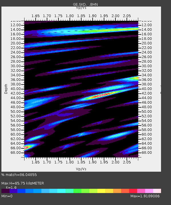
| Estimated Moho Depth: |
65.75 km |
| Estimated Crust Vp/Vs: |
1.60 |
| Assumed Crust Vp: |
5.55 km/s |
| Estimated Crust Vs: |
3.469 km/s |
| Estimated Crust Poisson's Ratio: |
0.18 |
|
| Radial Match: |
86.04855 % |
| Radial Bump: |
400 |
| Transverse Match: |
82.00504 % |
| Transverse Bump: |
400 |
| SOD ConfigId: |
3753 |
| Insert Time: |
2010-03-09 06:20:53.069 +0000 |
| GWidth: |
2.5 |
| Max Bumps: |
400 |
| Tol: |
0.001 |
|

Signal To Noise
| Channel | StoN | STA | LTA |
| GE:SKD: :BHN:20000815T20:32:50.272007Z | 3.819058 | 5.382059E-7 | 1.4092635E-7 |
| GE:SKD: :BHE:20000815T20:32:50.272007Z | 2.6243498 | 4.369963E-7 | 1.6651603E-7 |
| GE:SKD: :BHZ:20000815T20:32:50.272007Z | 9.346881 | 1.3858661E-6 | 1.4827044E-7 |
| Arrivals |
| Ps | 7.2 SECOND |
| PpPs | 30 SECOND |
| PsPs/PpSs | 37 SECOND |


