You are here: Home > Network List > GE - GEOFON Stations List
> Station SKD GEOFON Station Skordalos, Greece > Earthquake Result Viewer
SKD GEOFON Station Skordalos, Greece - Earthquake Result Viewer
| Earthquake location: |
Southern Alaska |
| Earthquake latitude/longitude: |
59.2/-153.1 |
| Earthquake time(UTC): |
2000/05/19 (140) 20:34:26 GMT |
| Earthquake Depth: |
80 km |
| Earthquake Magnitude: |
5.6 MB, 5.9 MW, 5.9 MW |
| Earthquake Catalog/Contributor: |
WHDF/NEIC |
|
| Network: |
GE GEOFON |
| Station: |
SKD GEOFON Station Skordalos, Greece |
| Lat/Lon: |
35.41 N/23.93 E |
| Elevation: |
306 m |
|
| Distance: |
85.7 deg |
| Az: |
2.402 deg |
| Baz: |
358.487 deg |
| Ray Param: |
0.04441623 |
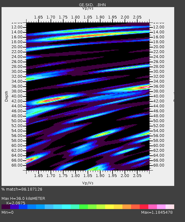
| Estimated Moho Depth: |
36.0 km |
| Estimated Crust Vp/Vs: |
2.10 |
| Assumed Crust Vp: |
5.55 km/s |
| Estimated Crust Vs: |
2.646 km/s |
| Estimated Crust Poisson's Ratio: |
0.35 |
|
| Radial Match: |
86.187126 % |
| Radial Bump: |
400 |
| Transverse Match: |
78.52886 % |
| Transverse Bump: |
400 |
| SOD ConfigId: |
3753 |
| Insert Time: |
2010-03-09 06:21:12.934 +0000 |
| GWidth: |
2.5 |
| Max Bumps: |
400 |
| Tol: |
0.001 |
|

Signal To Noise
| Channel | StoN | STA | LTA |
| GE:SKD: :BHN:20000519T20:46:25.071006Z | 5.6883755 | 4.368174E-7 | 7.679123E-8 |
| GE:SKD: :BHE:20000519T20:46:25.071006Z | 1.7896326 | 1.8320353E-7 | 1.02369356E-7 |
| GE:SKD: :BHZ:20000519T20:46:25.071006Z | 10.536041 | 7.9135725E-7 | 7.510955E-8 |
| Arrivals |
| Ps | 7.2 SECOND |
| PpPs | 20 SECOND |
| PsPs/PpSs | 27 SECOND |


