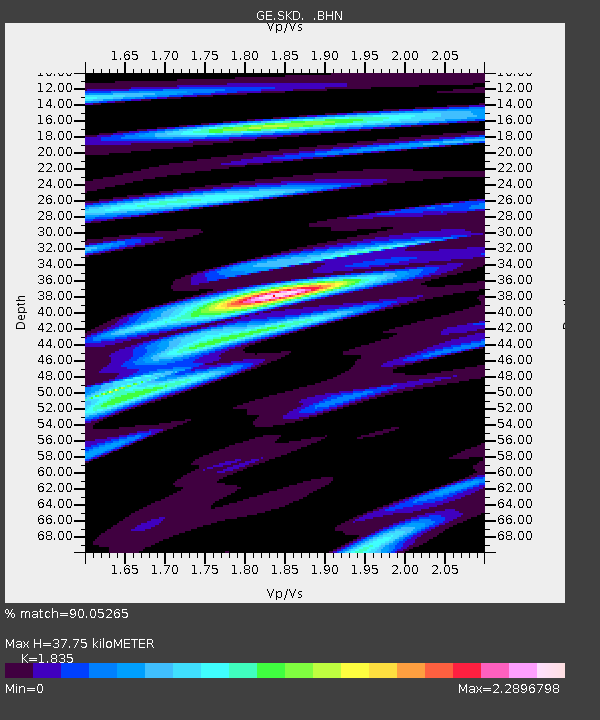
SKD GEOFON Station Skordalos, Greece - Earthquake Result Viewer

Earthquake location: Off W Coast Of Northern Sumatra
Earthquake latitude/longitude: 1.4/96.6
Earthquake time(UTC): 2000/09/01 (245) 11:56:51 GMT
Earthquake Depth: 33 km
Earthquake Magnitude: 5.6 MB, 6.0 MS, 6.2 MW, 6.0 MW
Earthquake Catalog/Contributor: WHDF/NEIC
Network: GE GEOFON
Station: SKD GEOFON Station Skordalos, Greece
Lat/Lon: 35.41 N/23.93 E
Elevation: 306 m
Distance: 75.1 deg
Az: 306.197 deg
Baz: 99.02 deg
Ray Param: 0.051868834
Estimated Moho Depth: 37.75 km
Estimated Crust Vp/Vs: 1.84
Assumed Crust Vp: 5.55 km/s
Estimated Crust Vs: 3.025 km/s
Estimated Crust Poisson's Ratio: 0.29
Radial Match: 90.05265 %
Radial Bump: 400
Transverse Match: 80.96027 %
Transverse Bump: 400
SOD ConfigId: 3744
Insert Time: 2010-03-09 06:21:14.154 +0000
GWidth: 2.5
Max Bumps: 400
Tol: 0.001

Signal To Noise

ChannelStoNSTALTA
GE:SKD: :BHN:20000901T12:07:59.272017Z1.29586761.205955E-79.30616E-8
GE:SKD: :BHE:20000901T12:07:59.272017Z2.67330462.017189E-77.545676E-8
GE:SKD: :BHZ:20000901T12:07:59.272017Z6.6821954.6480645E-76.955894E-8
Arrivals
Ps5.8 SECOND
PpPs19 SECOND
PsPs/PpSs25 SECOND