You are here: Home > Network List > GE - GEOFON Stations List
> Station SKD GEOFON Station Skordalos, Greece > Earthquake Result Viewer
SKD GEOFON Station Skordalos, Greece - Earthquake Result Viewer
| Earthquake location: |
Off Coast Of Oregon |
| Earthquake latitude/longitude: |
43.5/-127.2 |
| Earthquake time(UTC): |
2002/07/09 (190) 18:40:35 GMT |
| Earthquake Depth: |
10 km |
| Earthquake Magnitude: |
5.5 MB, 5.5 MS, 6.0 MW, 5.8 MW |
| Earthquake Catalog/Contributor: |
WHDF/NEIC |
|
| Network: |
GE GEOFON |
| Station: |
SKD GEOFON Station Skordalos, Greece |
| Lat/Lon: |
35.41 N/23.93 E |
| Elevation: |
306 m |
|
| Distance: |
97.1 deg |
| Az: |
23.446 deg |
| Baz: |
339.246 deg |
| Ray Param: |
0.040302757 |
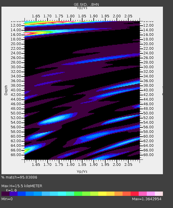
| Estimated Moho Depth: |
15.5 km |
| Estimated Crust Vp/Vs: |
1.60 |
| Assumed Crust Vp: |
5.55 km/s |
| Estimated Crust Vs: |
3.469 km/s |
| Estimated Crust Poisson's Ratio: |
0.18 |
|
| Radial Match: |
95.83886 % |
| Radial Bump: |
296 |
| Transverse Match: |
73.08231 % |
| Transverse Bump: |
400 |
| SOD ConfigId: |
20082 |
| Insert Time: |
2010-03-09 06:21:38.301 +0000 |
| GWidth: |
2.5 |
| Max Bumps: |
400 |
| Tol: |
0.001 |
|

Signal To Noise
| Channel | StoN | STA | LTA |
| GE:SKD: :BHN:20020709T18:53:36.327021Z | 0.9208115 | 1.2168351E-6 | 1.3214812E-6 |
| GE:SKD: :BHE:20020709T18:53:36.327021Z | 0.9224044 | 7.110981E-7 | 7.7091795E-7 |
| GE:SKD: :BHZ:20020709T18:53:36.327021Z | 0.90596724 | 9.0825586E-7 | 1.0025262E-6 |
| Arrivals |
| Ps | 1.7 SECOND |
| PpPs | 7.1 SECOND |
| PsPs/PpSs | 8.8 SECOND |


