You are here: Home > Network List > GE - GEOFON Stations List
> Station SKD GEOFON Station Skordalos, Greece > Earthquake Result Viewer
SKD GEOFON Station Skordalos, Greece - Earthquake Result Viewer
| Earthquake location: |
Central Alaska |
| Earthquake latitude/longitude: |
63.5/-147.4 |
| Earthquake time(UTC): |
2002/11/03 (307) 22:12:41 GMT |
| Earthquake Depth: |
4.9 km |
| Earthquake Magnitude: |
7.0 MB, 8.5 MS, 7.9 MW |
| Earthquake Catalog/Contributor: |
WHDF/NEIC |
|
| Network: |
GE GEOFON |
| Station: |
SKD GEOFON Station Skordalos, Greece |
| Lat/Lon: |
35.41 N/23.93 E |
| Elevation: |
306 m |
|
| Distance: |
81.2 deg |
| Az: |
7.124 deg |
| Baz: |
356.097 deg |
| Ray Param: |
0.04778693 |
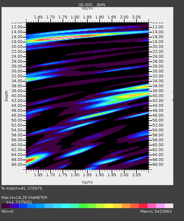
| Estimated Moho Depth: |
16.25 km |
| Estimated Crust Vp/Vs: |
1.74 |
| Assumed Crust Vp: |
5.55 km/s |
| Estimated Crust Vs: |
3.194 km/s |
| Estimated Crust Poisson's Ratio: |
0.25 |
|
| Radial Match: |
91.370575 % |
| Radial Bump: |
400 |
| Transverse Match: |
85.162254 % |
| Transverse Bump: |
400 |
| SOD ConfigId: |
4714 |
| Insert Time: |
2010-03-09 06:21:46.123 +0000 |
| GWidth: |
2.5 |
| Max Bumps: |
400 |
| Tol: |
0.001 |
|

Signal To Noise
| Channel | StoN | STA | LTA |
| GE:SKD: :BHN:20021103T22:24:26.101013Z | 36.387135 | 3.8014036E-6 | 1.0447109E-7 |
| GE:SKD: :BHE:20021103T22:24:26.101013Z | 14.583485 | 1.4322505E-6 | 9.821045E-8 |
| GE:SKD: :BHZ:20021103T22:24:26.101013Z | 68.530624 | 6.6373645E-6 | 9.685254E-8 |
| Arrivals |
| Ps | 2.2 SECOND |
| PpPs | 7.9 SECOND |
| PsPs/PpSs | 10 SECOND |


