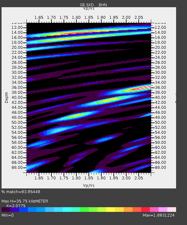
SKD GEOFON Station Skordalos, Greece - Earthquake Result Viewer

Earthquake location: Rat Islands, Aleutian Islands
Earthquake latitude/longitude: 51.6/176.9
Earthquake time(UTC): 2003/06/15 (166) 19:24:33 GMT
Earthquake Depth: 20 km
Earthquake Magnitude: 6.0 MB, 6.4 MS, 6.5 MW, 6.5 MW
Earthquake Catalog/Contributor: WHDF/NEIC
Network: GE GEOFON
Station: SKD GEOFON Station Skordalos, Greece
Lat/Lon: 35.41 N/23.93 E
Elevation: 306 m
Distance: 90.2 deg
Az: 338.229 deg
Baz: 16.47 deg
Ray Param: 0.04168753
Estimated Moho Depth: 35.75 km
Estimated Crust Vp/Vs: 2.08
Assumed Crust Vp: 5.55 km/s
Estimated Crust Vs: 2.671 km/s
Estimated Crust Poisson's Ratio: 0.35
Radial Match: 93.95449 %
Radial Bump: 400
Transverse Match: 90.35787 %
Transverse Bump: 400
SOD ConfigId: 4714
Insert Time: 2010-03-09 06:21:55.533 +0000
GWidth: 2.5
Max Bumps: 400
Tol: 0.001

Signal To Noise

ChannelStoNSTALTA
GE:SKD: :BHN:20030615T19:37:00.663Z4.102573.8136602E-79.295783E-8
GE:SKD: :BHE:20030615T19:37:00.663Z1.81115442.3350829E-71.2892787E-7
GE:SKD: :BHZ:20030615T19:37:00.663Z17.249691.0527864E-66.1032196E-8
Arrivals
Ps7.0 SECOND
PpPs20 SECOND
PsPs/PpSs27 SECOND