You are here: Home > Network List > GE - GEOFON Stations List
> Station SKD GEOFON Station Skordalos, Greece > Earthquake Result Viewer
SKD GEOFON Station Skordalos, Greece - Earthquake Result Viewer
| Earthquake location: |
Ryukyu Islands, Japan |
| Earthquake latitude/longitude: |
26.5/128.9 |
| Earthquake time(UTC): |
2004/07/22 (204) 09:45:14 GMT |
| Earthquake Depth: |
21 km |
| Earthquake Magnitude: |
6.1 MB, 5.7 MS, 6.1 MW, 6.1 MW |
| Earthquake Catalog/Contributor: |
WHDF/NEIC |
|
| Network: |
GE GEOFON |
| Station: |
SKD GEOFON Station Skordalos, Greece |
| Lat/Lon: |
35.41 N/23.93 E |
| Elevation: |
306 m |
|
| Distance: |
86.2 deg |
| Az: |
307.73 deg |
| Baz: |
60.198 deg |
| Ray Param: |
0.044226162 |
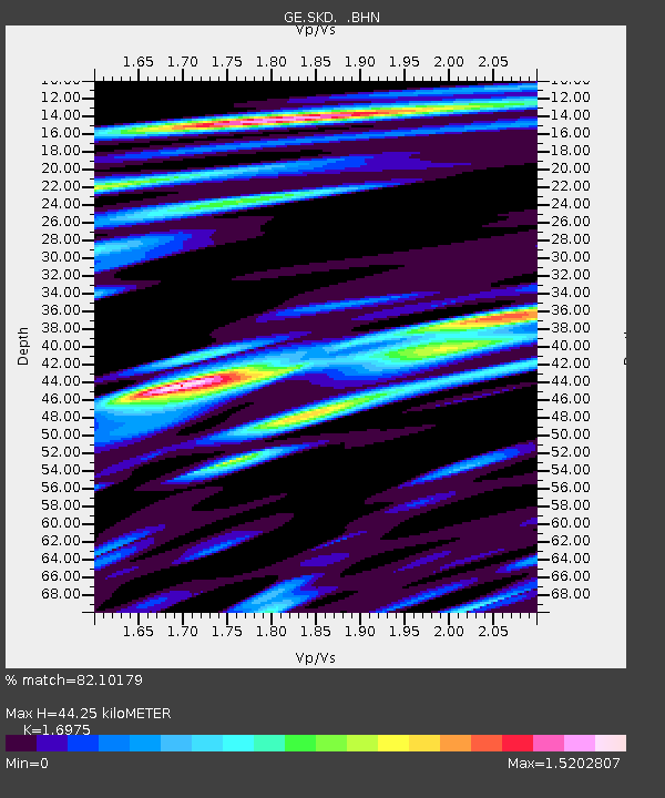
| Estimated Moho Depth: |
44.25 km |
| Estimated Crust Vp/Vs: |
1.70 |
| Assumed Crust Vp: |
5.55 km/s |
| Estimated Crust Vs: |
3.27 km/s |
| Estimated Crust Poisson's Ratio: |
0.23 |
|
| Radial Match: |
82.10179 % |
| Radial Bump: |
400 |
| Transverse Match: |
79.75087 % |
| Transverse Bump: |
400 |
| SOD ConfigId: |
2459 |
| Insert Time: |
2010-03-09 06:22:01.941 +0000 |
| GWidth: |
2.5 |
| Max Bumps: |
400 |
| Tol: |
0.001 |
|

Signal To Noise
| Channel | StoN | STA | LTA |
| GE:SKD: :BHN:20040722T09:57:23.006018Z | 1.0047348 | 3.2424893E-7 | 3.227209E-7 |
| GE:SKD: :BHE:20040722T09:57:23.037024Z | 1.7560103 | 4.412773E-7 | 2.512954E-7 |
| GE:SKD: :BHZ:20040722T09:57:23.045996Z | 4.0835915 | 1.009939E-6 | 2.4731634E-7 |
| Arrivals |
| Ps | 5.7 SECOND |
| PpPs | 21 SECOND |
| PsPs/PpSs | 27 SECOND |


