You are here: Home > Network List > GE - GEOFON Stations List
> Station SKD GEOFON Station Skordalos, Greece > Earthquake Result Viewer
SKD GEOFON Station Skordalos, Greece - Earthquake Result Viewer
| Earthquake location: |
Jan Mayen Island Region |
| Earthquake latitude/longitude: |
71.1/-7.7 |
| Earthquake time(UTC): |
2004/04/14 (105) 23:07:39 GMT |
| Earthquake Depth: |
12 km |
| Earthquake Magnitude: |
5.8 MB, 5.6 MS, 6.0 MW, 6.0 MW |
| Earthquake Catalog/Contributor: |
WHDF/NEIC |
|
| Network: |
GE GEOFON |
| Station: |
SKD GEOFON Station Skordalos, Greece |
| Lat/Lon: |
35.41 N/23.93 E |
| Elevation: |
306 m |
|
| Distance: |
39.4 deg |
| Az: |
137.543 deg |
| Baz: |
344.35 deg |
| Ray Param: |
0.074971914 |
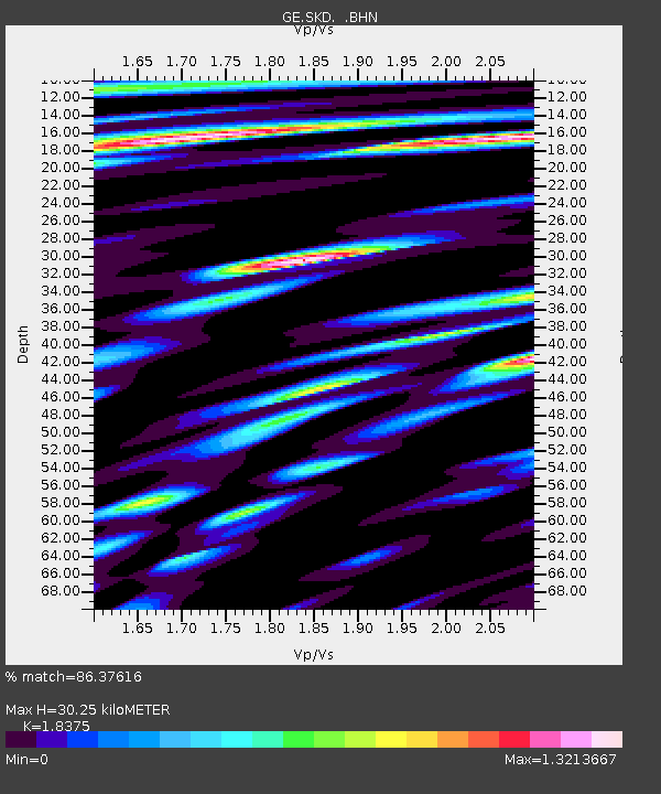
| Estimated Moho Depth: |
30.25 km |
| Estimated Crust Vp/Vs: |
1.84 |
| Assumed Crust Vp: |
5.55 km/s |
| Estimated Crust Vs: |
3.02 km/s |
| Estimated Crust Poisson's Ratio: |
0.29 |
|
| Radial Match: |
86.37616 % |
| Radial Bump: |
400 |
| Transverse Match: |
84.25719 % |
| Transverse Bump: |
400 |
| SOD ConfigId: |
2459 |
| Insert Time: |
2010-03-09 06:22:04.613 +0000 |
| GWidth: |
2.5 |
| Max Bumps: |
400 |
| Tol: |
0.001 |
|

Signal To Noise
| Channel | StoN | STA | LTA |
| GE:SKD: :BHN:20040414T23:14:38.980985Z | 3.1380093 | 1.22397E-6 | 3.9004664E-7 |
| GE:SKD: :BHE:20040414T23:14:39.022001Z | 1.4194168 | 7.135451E-7 | 5.02703E-7 |
| GE:SKD: :BHZ:20040414T23:14:39.011014Z | 7.066125 | 2.2916147E-6 | 3.2430998E-7 |
| Arrivals |
| Ps | 4.8 SECOND |
| PpPs | 15 SECOND |
| PsPs/PpSs | 20 SECOND |


