You are here: Home > Network List > GE - GEOFON Stations List
> Station SKD GEOFON Station Skordalos, Greece > Earthquake Result Viewer
SKD GEOFON Station Skordalos, Greece - Earthquake Result Viewer
| Earthquake location: |
Afghanistan-Tajikistan Bord Reg. |
| Earthquake latitude/longitude: |
36.5/71.0 |
| Earthquake time(UTC): |
2004/04/05 (096) 21:24:04 GMT |
| Earthquake Depth: |
187 km |
| Earthquake Magnitude: |
6.4 MB, 6.6 MW, 6.5 MW |
| Earthquake Catalog/Contributor: |
WHDF/NEIC |
|
| Network: |
GE GEOFON |
| Station: |
SKD GEOFON Station Skordalos, Greece |
| Lat/Lon: |
35.41 N/23.93 E |
| Elevation: |
306 m |
|
| Distance: |
37.8 deg |
| Az: |
282.745 deg |
| Baz: |
74.151 deg |
| Ray Param: |
0.07520203 |
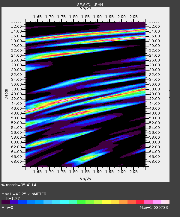
| Estimated Moho Depth: |
42.25 km |
| Estimated Crust Vp/Vs: |
1.77 |
| Assumed Crust Vp: |
5.55 km/s |
| Estimated Crust Vs: |
3.136 km/s |
| Estimated Crust Poisson's Ratio: |
0.27 |
|
| Radial Match: |
85.4114 % |
| Radial Bump: |
400 |
| Transverse Match: |
77.57821 % |
| Transverse Bump: |
400 |
| SOD ConfigId: |
2459 |
| Insert Time: |
2010-03-09 06:22:06.058 +0000 |
| GWidth: |
2.5 |
| Max Bumps: |
400 |
| Tol: |
0.001 |
|

Signal To Noise
| Channel | StoN | STA | LTA |
| GE:SKD: :BHN:20040405T21:30:32.113007Z | 35.935673 | 3.6830704E-6 | 1.0249065E-7 |
| GE:SKD: :BHE:20040405T21:30:32.10199Z | 79.960014 | 8.950366E-6 | 1.1193551E-7 |
| GE:SKD: :BHZ:20040405T21:30:32.10199Z | 131.20468 | 1.2435107E-5 | 9.47764E-8 |
| Arrivals |
| Ps | 6.2 SECOND |
| PpPs | 20 SECOND |
| PsPs/PpSs | 26 SECOND |


