You are here: Home > Network List > GE - GEOFON Stations List
> Station KWP GEOFON Station Kalwaria Paclawska, Poland > Earthquake Result Viewer
KWP GEOFON Station Kalwaria Paclawska, Poland - Earthquake Result Viewer
| Earthquake location: |
South Of Java, Indonesia |
| Earthquake latitude/longitude: |
-9.3/107.4 |
| Earthquake time(UTC): |
2006/07/17 (198) 08:19:28 GMT |
| Earthquake Depth: |
34 km |
| Earthquake Magnitude: |
6.1 MB, 7.2 MS, 7.7 MW, 7.2 MW |
| Earthquake Catalog/Contributor: |
WHDF/NEIC |
|
| Network: |
GE GEOFON |
| Station: |
KWP GEOFON Station Kalwaria Paclawska, Poland |
| Lat/Lon: |
49.63 N/22.71 E |
| Elevation: |
463 m |
|
| Distance: |
93.6 deg |
| Az: |
319.555 deg |
| Baz: |
99.989 deg |
| Ray Param: |
0.0412249 |
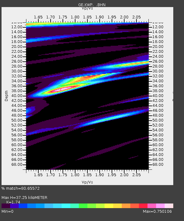
| Estimated Moho Depth: |
37.25 km |
| Estimated Crust Vp/Vs: |
1.74 |
| Assumed Crust Vp: |
6.53 km/s |
| Estimated Crust Vs: |
3.753 km/s |
| Estimated Crust Poisson's Ratio: |
0.25 |
|
| Radial Match: |
80.65572 % |
| Radial Bump: |
400 |
| Transverse Match: |
80.27581 % |
| Transverse Bump: |
400 |
| SOD ConfigId: |
2665 |
| Insert Time: |
2010-03-09 06:22:53.101 +0000 |
| GWidth: |
2.5 |
| Max Bumps: |
400 |
| Tol: |
0.001 |
|

Signal To Noise
| Channel | StoN | STA | LTA |
| GE:KWP: :BHN:20060717T08:32:09.91803Z | 0.69460565 | 1.730774E-7 | 2.491736E-7 |
| GE:KWP: :BHE:20060717T08:32:09.91803Z | 0.9238825 | 4.9940854E-7 | 5.4055414E-7 |
| GE:KWP: :BHZ:20060717T08:32:09.91803Z | 3.8537421 | 5.5264843E-7 | 1.4340566E-7 |
| Arrivals |
| Ps | 4.3 SECOND |
| PpPs | 15 SECOND |
| PsPs/PpSs | 20 SECOND |


