You are here: Home > Network List > GE - GEOFON Stations List
> Station KWP GEOFON Station Kalwaria Paclawska, Poland > Earthquake Result Viewer
KWP GEOFON Station Kalwaria Paclawska, Poland - Earthquake Result Viewer
| Earthquake location: |
Southern India |
| Earthquake latitude/longitude: |
23.4/70.2 |
| Earthquake time(UTC): |
2001/01/26 (026) 03:16:40 GMT |
| Earthquake Depth: |
16 km |
| Earthquake Magnitude: |
6.9 MB, 8.0 MS, 7.7 MW, 7.7 ME |
| Earthquake Catalog/Contributor: |
WHDF/NEIC |
|
| Network: |
GE GEOFON |
| Station: |
KWP GEOFON Station Kalwaria Paclawska, Poland |
| Lat/Lon: |
49.63 N/22.71 E |
| Elevation: |
463 m |
|
| Distance: |
45.3 deg |
| Az: |
317.553 deg |
| Baz: |
107.551 deg |
| Ray Param: |
0.07136376 |
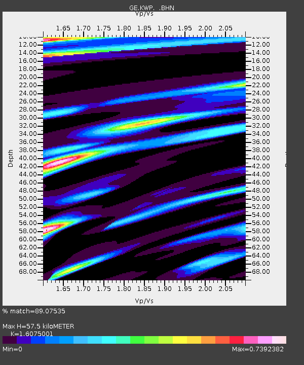
| Estimated Moho Depth: |
57.5 km |
| Estimated Crust Vp/Vs: |
1.61 |
| Assumed Crust Vp: |
6.53 km/s |
| Estimated Crust Vs: |
4.062 km/s |
| Estimated Crust Poisson's Ratio: |
0.18 |
|
| Radial Match: |
89.07535 % |
| Radial Bump: |
400 |
| Transverse Match: |
87.29121 % |
| Transverse Bump: |
400 |
| SOD ConfigId: |
3744 |
| Insert Time: |
2010-03-09 06:23:05.200 +0000 |
| GWidth: |
2.5 |
| Max Bumps: |
400 |
| Tol: |
0.001 |
|

Signal To Noise
| Channel | StoN | STA | LTA |
| GE:KWP: :BHN:20010126T03:24:26.424011Z | 0.6472778 | 4.3674078E-7 | 6.7473474E-7 |
| GE:KWP: :BHE:20010126T03:24:26.424011Z | 3.5925038 | 1.5022608E-6 | 4.181654E-7 |
| GE:KWP: :BHZ:20010126T03:24:26.424011Z | 11.97854 | 3.824851E-6 | 3.1930855E-7 |
| Arrivals |
| Ps | 5.8 SECOND |
| PpPs | 21 SECOND |
| PsPs/PpSs | 27 SECOND |


