You are here: Home > Network List > GE - GEOFON Stations List
> Station KWP GEOFON Station Kalwaria Paclawska, Poland > Earthquake Result Viewer
KWP GEOFON Station Kalwaria Paclawska, Poland - Earthquake Result Viewer
| Earthquake location: |
El Salvador |
| Earthquake latitude/longitude: |
13.0/-88.7 |
| Earthquake time(UTC): |
2001/01/13 (013) 17:33:32 GMT |
| Earthquake Depth: |
60 km |
| Earthquake Magnitude: |
6.4 MB, 7.8 MS, 7.7 MW, 7.5 ME |
| Earthquake Catalog/Contributor: |
WHDF/NEIC |
|
| Network: |
GE GEOFON |
| Station: |
KWP GEOFON Station Kalwaria Paclawska, Poland |
| Lat/Lon: |
49.63 N/22.71 E |
| Elevation: |
463 m |
|
| Distance: |
93.5 deg |
| Az: |
37.348 deg |
| Baz: |
294.607 deg |
| Ray Param: |
0.0412277 |
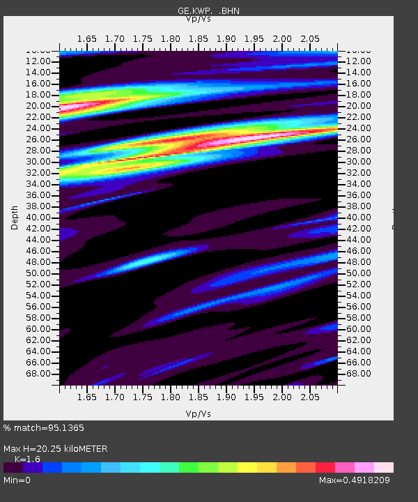
| Estimated Moho Depth: |
20.25 km |
| Estimated Crust Vp/Vs: |
1.60 |
| Assumed Crust Vp: |
6.53 km/s |
| Estimated Crust Vs: |
4.082 km/s |
| Estimated Crust Poisson's Ratio: |
0.18 |
|
| Radial Match: |
95.1365 % |
| Radial Bump: |
400 |
| Transverse Match: |
84.85655 % |
| Transverse Bump: |
400 |
| SOD ConfigId: |
3744 |
| Insert Time: |
2010-03-09 06:23:06.326 +0000 |
| GWidth: |
2.5 |
| Max Bumps: |
400 |
| Tol: |
0.001 |
|

Signal To Noise
| Channel | StoN | STA | LTA |
| GE:KWP: :BHN:20010113T17:46:10.075007Z | 1.148934 | 5.758048E-7 | 5.011644E-7 |
| GE:KWP: :BHE:20010113T17:46:10.075007Z | 1.8312348 | 5.5329974E-7 | 3.021457E-7 |
| GE:KWP: :BHZ:20010113T17:46:10.075007Z | 4.952974 | 1.0362234E-6 | 2.0921236E-7 |
| Arrivals |
| Ps | 1.9 SECOND |
| PpPs | 7.9 SECOND |
| PsPs/PpSs | 9.8 SECOND |


