You are here: Home > Network List > GE - GEOFON Stations List
> Station KWP GEOFON Station Kalwaria Paclawska, Poland > Earthquake Result Viewer
KWP GEOFON Station Kalwaria Paclawska, Poland - Earthquake Result Viewer
| Earthquake location: |
Hindu Kush Region, Afghanistan |
| Earthquake latitude/longitude: |
36.4/70.4 |
| Earthquake time(UTC): |
2002/03/03 (062) 12:08:07 GMT |
| Earthquake Depth: |
209 km |
| Earthquake Magnitude: |
6.3 MB |
| Earthquake Catalog/Contributor: |
WHDF/NEIC |
|
| Network: |
GE GEOFON |
| Station: |
KWP GEOFON Station Kalwaria Paclawska, Poland |
| Lat/Lon: |
49.63 N/22.71 E |
| Elevation: |
463 m |
|
| Distance: |
36.7 deg |
| Az: |
306.352 deg |
| Baz: |
92.655 deg |
| Ray Param: |
0.07576208 |
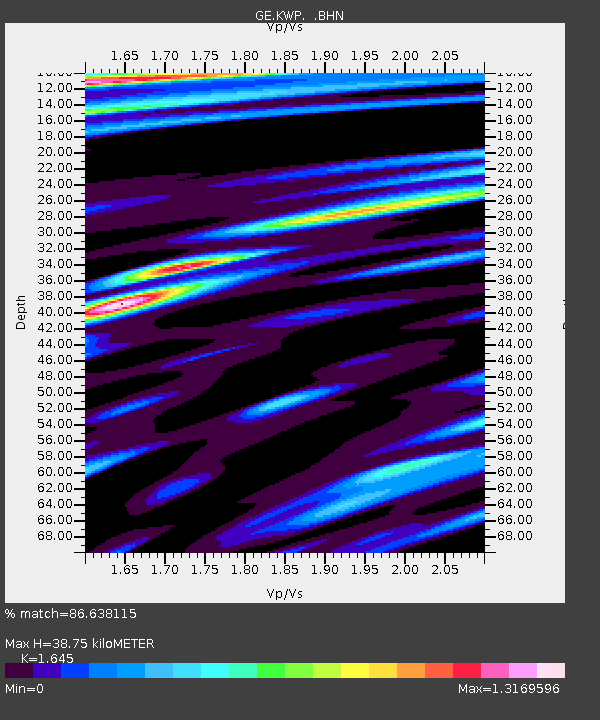
| Estimated Moho Depth: |
38.75 km |
| Estimated Crust Vp/Vs: |
1.64 |
| Assumed Crust Vp: |
6.53 km/s |
| Estimated Crust Vs: |
3.97 km/s |
| Estimated Crust Poisson's Ratio: |
0.21 |
|
| Radial Match: |
86.638115 % |
| Radial Bump: |
397 |
| Transverse Match: |
81.217865 % |
| Transverse Bump: |
399 |
| SOD ConfigId: |
20082 |
| Insert Time: |
2010-03-09 06:23:20.016 +0000 |
| GWidth: |
2.5 |
| Max Bumps: |
400 |
| Tol: |
0.001 |
|

Signal To Noise
| Channel | StoN | STA | LTA |
| GE:KWP: :BHN:20020303T12:14:24.08301Z | 1.0795503 | 9.802633E-7 | 9.080294E-7 |
| GE:KWP: :BHE:20020303T12:14:24.08301Z | 2.8822536 | 1.8635168E-6 | 6.4654853E-7 |
| GE:KWP: :BHZ:20020303T12:14:24.08301Z | 3.4271529 | 3.2352852E-6 | 9.440155E-7 |
| Arrivals |
| Ps | 4.2 SECOND |
| PpPs | 14 SECOND |
| PsPs/PpSs | 19 SECOND |


