You are here: Home > Network List > GE - GEOFON Stations List
> Station KWP GEOFON Station Kalwaria Paclawska, Poland > Earthquake Result Viewer
KWP GEOFON Station Kalwaria Paclawska, Poland - Earthquake Result Viewer
| Earthquake location: |
Northwestern Kashmir |
| Earthquake latitude/longitude: |
35.4/74.5 |
| Earthquake time(UTC): |
2002/11/20 (324) 21:32:30 GMT |
| Earthquake Depth: |
33 km |
| Earthquake Magnitude: |
5.7 MB, 6.5 MS, 6.4 MW, 6.0 MW |
| Earthquake Catalog/Contributor: |
WHDF/NEIC |
|
| Network: |
GE GEOFON |
| Station: |
KWP GEOFON Station Kalwaria Paclawska, Poland |
| Lat/Lon: |
49.63 N/22.71 E |
| Elevation: |
463 m |
|
| Distance: |
39.9 deg |
| Az: |
307.251 deg |
| Baz: |
90.766 deg |
| Ray Param: |
0.07461828 |
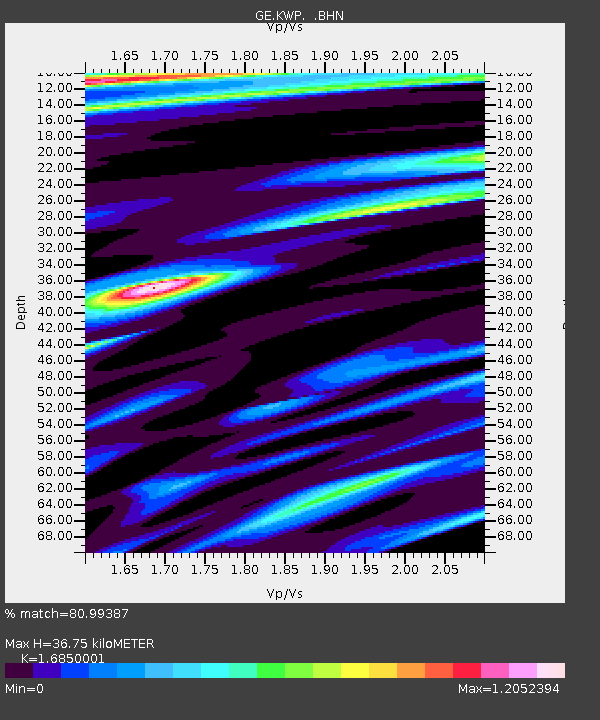
| Estimated Moho Depth: |
36.75 km |
| Estimated Crust Vp/Vs: |
1.69 |
| Assumed Crust Vp: |
6.53 km/s |
| Estimated Crust Vs: |
3.876 km/s |
| Estimated Crust Poisson's Ratio: |
0.23 |
|
| Radial Match: |
80.99387 % |
| Radial Bump: |
400 |
| Transverse Match: |
75.961464 % |
| Transverse Bump: |
367 |
| SOD ConfigId: |
4714 |
| Insert Time: |
2010-03-09 06:23:23.276 +0000 |
| GWidth: |
2.5 |
| Max Bumps: |
400 |
| Tol: |
0.001 |
|

Signal To Noise
| Channel | StoN | STA | LTA |
| GE:KWP: :BHN:20021120T21:39:31.497012Z | 0.6351386 | 1.557556E-7 | 2.452309E-7 |
| GE:KWP: :BHE:20021120T21:39:31.497012Z | 2.368433 | 5.605292E-7 | 2.366667E-7 |
| GE:KWP: :BHZ:20021120T21:39:31.497012Z | 1.9971001 | 5.3819514E-7 | 2.6948828E-7 |
| Arrivals |
| Ps | 4.2 SECOND |
| PpPs | 14 SECOND |
| PsPs/PpSs | 18 SECOND |


