You are here: Home > Network List > GE - GEOFON Stations List
> Station KWP GEOFON Station Kalwaria Paclawska, Poland > Earthquake Result Viewer
KWP GEOFON Station Kalwaria Paclawska, Poland - Earthquake Result Viewer
| Earthquake location: |
Lake Tanganyika Region |
| Earthquake latitude/longitude: |
-6.2/29.8 |
| Earthquake time(UTC): |
2005/12/05 (339) 12:19:56 GMT |
| Earthquake Depth: |
22 km |
| Earthquake Magnitude: |
6.4 MB, 7.2 MS, 6.8 MW, 6.7 MW |
| Earthquake Catalog/Contributor: |
WHDF/NEIC |
|
| Network: |
GE GEOFON |
| Station: |
KWP GEOFON Station Kalwaria Paclawska, Poland |
| Lat/Lon: |
49.63 N/22.71 E |
| Elevation: |
463 m |
|
| Distance: |
56.0 deg |
| Az: |
354.417 deg |
| Baz: |
171.446 deg |
| Ray Param: |
0.06441845 |
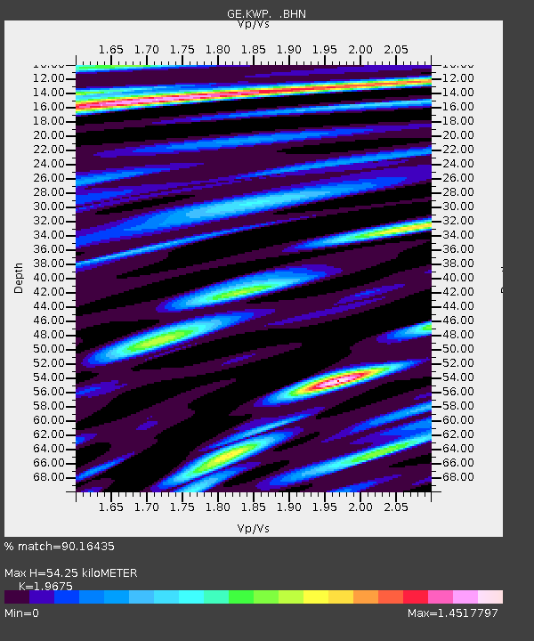
| Estimated Moho Depth: |
54.25 km |
| Estimated Crust Vp/Vs: |
1.97 |
| Assumed Crust Vp: |
6.53 km/s |
| Estimated Crust Vs: |
3.319 km/s |
| Estimated Crust Poisson's Ratio: |
0.33 |
|
| Radial Match: |
90.16435 % |
| Radial Bump: |
400 |
| Transverse Match: |
78.449905 % |
| Transverse Bump: |
400 |
| SOD ConfigId: |
2422 |
| Insert Time: |
2010-03-09 06:23:39.661 +0000 |
| GWidth: |
2.5 |
| Max Bumps: |
400 |
| Tol: |
0.001 |
|

Signal To Noise
| Channel | StoN | STA | LTA |
| GE:KWP: :BHN:20051205T12:29:02.221013Z | 6.3205147 | 1.6575376E-6 | 2.6224726E-7 |
| GE:KWP: :BHE:20051205T12:29:02.221013Z | 4.500275 | 1.0695716E-6 | 2.3766805E-7 |
| GE:KWP: :BHZ:20051205T12:29:02.221013Z | 20.903921 | 4.031166E-6 | 1.9284258E-7 |
| Arrivals |
| Ps | 8.4 SECOND |
| PpPs | 24 SECOND |
| PsPs/PpSs | 32 SECOND |


