You are here: Home > Network List > XW97 - Tien Shan Continental Dynamics Stations List
> Station KARL XW.KARL > Earthquake Result Viewer
KARL XW.KARL - Earthquake Result Viewer
| Earthquake location: |
Bonin Islands, Japan Region |
| Earthquake latitude/longitude: |
28.9/139.6 |
| Earthquake time(UTC): |
2000/08/06 (219) 07:27:12 GMT |
| Earthquake Depth: |
395 km |
| Earthquake Magnitude: |
6.3 MB, 7.3 MW, 7.3 MW |
| Earthquake Catalog/Contributor: |
WHDF/NEIC |
|
| Network: |
XW Tien Shan Continental Dynamics |
| Station: |
KARL XW.KARL |
| Lat/Lon: |
41.47 N/77.31 E |
| Elevation: |
3021 m |
|
| Distance: |
51.4 deg |
| Az: |
301.701 deg |
| Baz: |
83.293 deg |
| Ray Param: |
0.06582008 |
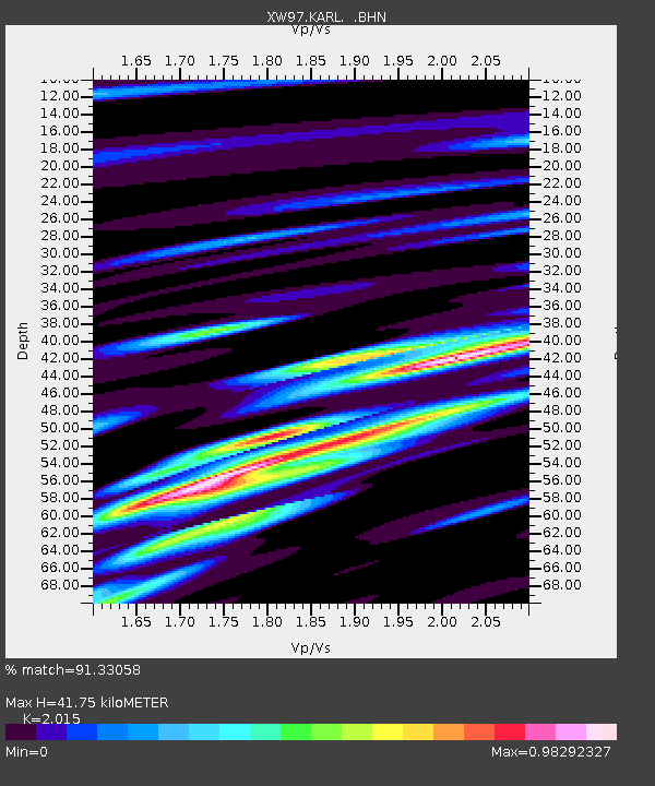
| Estimated Moho Depth: |
41.75 km |
| Estimated Crust Vp/Vs: |
2.02 |
| Assumed Crust Vp: |
6.491 km/s |
| Estimated Crust Vs: |
3.221 km/s |
| Estimated Crust Poisson's Ratio: |
0.34 |
|
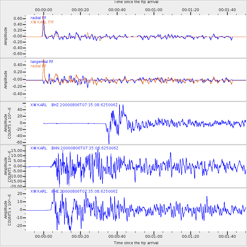
| Radial Match: |
91.33058 % |
| Radial Bump: |
400 |
| Transverse Match: |
85.16182 % |
| Transverse Bump: |
400 |
| SOD ConfigId: |
20082 |
| Insert Time: |
2010-02-26 15:26:18.750 +0000 |
| GWidth: |
2.5 |
| Max Bumps: |
400 |
| Tol: |
0.001 |
|
Signal To Noise
| Channel | StoN | STA | LTA |
| XW:KARL: :BHN:20000806T07:35:08.625006Z | 12.161717 | 5.06774E-7 | 4.1669608E-8 |
| XW:KARL: :BHE:20000806T07:35:08.625006Z | 54.46612 | 2.836411E-6 | 5.207661E-8 |
| XW:KARL: :BHZ:20000806T07:35:08.625006Z | 116.577644 | 7.329153E-6 | 6.286928E-8 |
| Arrivals |
| Ps | 6.9 SECOND |
| PpPs | 18 SECOND |
| PsPs/PpSs | 25 SECOND |


