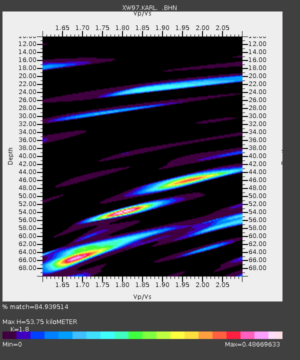
KARL XW.KARL - Earthquake Result Viewer
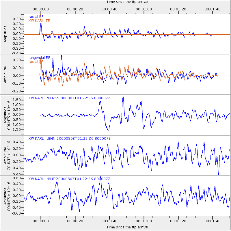
Earthquake location: Santa Cruz Islands
Earthquake latitude/longitude: -12.0/166.4
Earthquake time(UTC): 2000/08/03 (216) 01:09:38 GMT
Earthquake Depth: 33 km
Earthquake Magnitude: 5.7 MB, 6.5 MS, 6.7 MW, 6.6 MW
Earthquake Catalog/Contributor: WHDF/NEIC
Network: XW Tien Shan Continental Dynamics
Station: KARL XW.KARL
Lat/Lon: 41.47 N/77.31 E
Elevation: 3021 m
Distance: 97.2 deg
Az: 310.766 deg
Baz: 99.598 deg
Ray Param: 0.040264167
Estimated Moho Depth: 53.75 km
Estimated Crust Vp/Vs: 1.80
Assumed Crust Vp: 6.491 km/s
Estimated Crust Vs: 3.606 km/s
Estimated Crust Poisson's Ratio: 0.28
Radial Match: 84.939514 %
Radial Bump: 400
Transverse Match: 80.157394 %
Transverse Bump: 400
SOD ConfigId: 20082
Insert Time: 2010-02-26 15:26:21.490 +0000
GWidth: 2.5
Max Bumps: 400
Tol: 0.001

Signal To Noise

ChannelStoNSTALTA
XW:KARL: :BHN:20000803T01:22:36.800007Z1.05864918.244013E-87.7872954E-8
XW:KARL: :BHE:20000803T01:22:36.800007Z1.5303291.13220736E-77.398458E-8
XW:KARL: :BHZ:20000803T01:22:36.800007Z7.0400465.627285E-77.99325E-8
Arrivals
Ps6.8 SECOND
PpPs23 SECOND
PsPs/PpSs29 SECOND