You are here: Home > Network List > XW97 - Tien Shan Continental Dynamics Stations List
> Station KARL XW.KARL > Earthquake Result Viewer
KARL XW.KARL - Earthquake Result Viewer

| Earthquake location: |
Southern Sumatra, Indonesia |
| Earthquake latitude/longitude: |
-4.1/102.4 |
| Earthquake time(UTC): |
2000/07/22 (204) 20:56:12 GMT |
| Earthquake Depth: |
69 km |
| Earthquake Magnitude: |
5.8 MB, 5.8 MW, 5.7 MW |
| Earthquake Catalog/Contributor: |
WHDF/NEIC |
|
| Network: |
XW Tien Shan Continental Dynamics |
| Station: |
KARL XW.KARL |
| Lat/Lon: |
41.47 N/77.31 E |
| Elevation: |
3021 m |
|
| Distance: |
50.8 deg |
| Az: |
335.735 deg |
| Baz: |
146.94 deg |
| Ray Param: |
0.06764274 |
| Estimated Moho Depth: |
53.0 km |
| Estimated Crust Vp/Vs: |
1.82 |
| Assumed Crust Vp: |
6.491 km/s |
| Estimated Crust Vs: |
3.571 km/s |
| Estimated Crust Poisson's Ratio: |
0.28 |
|
| Radial Match: |
86.14259 % |
| Radial Bump: |
400 |
| Transverse Match: |
82.86489 % |
| Transverse Bump: |
400 |
| SOD ConfigId: |
20082 |
| Insert Time: |
2010-02-26 15:26:24.141 +0000 |
| GWidth: |
2.5 |
| Max Bumps: |
400 |
| Tol: |
0.001 |
|
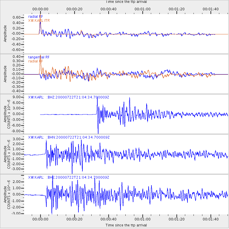
Signal To Noise
| Channel | StoN | STA | LTA |
| XW:KARL: :BHN:20000722T21:04:34.700009Z | 7.6919246 | 8.905928E-7 | 1.1578283E-7 |
| XW:KARL: :BHE:20000722T21:04:34.700009Z | 4.707597 | 5.364169E-7 | 1.1394708E-7 |
| XW:KARL: :BHZ:20000722T21:04:34.700009Z | 73.836685 | 3.1101033E-6 | 4.2121382E-8 |
| Arrivals |
| Ps | 7.1 SECOND |
| PpPs | 22 SECOND |
| PsPs/PpSs | 29 SECOND |


