You are here: Home > Network List > XW97 - Tien Shan Continental Dynamics Stations List
> Station KARL XW.KARL > Earthquake Result Viewer
KARL XW.KARL - Earthquake Result Viewer
| Earthquake location: |
Sea Of Okhotsk |
| Earthquake latitude/longitude: |
46.8/145.4 |
| Earthquake time(UTC): |
2000/07/10 (192) 09:58:18 GMT |
| Earthquake Depth: |
360 km |
| Earthquake Magnitude: |
6.1 MB, 5.9 MW, 5.8 MW |
| Earthquake Catalog/Contributor: |
WHDF/NEIC |
|
| Network: |
XW Tien Shan Continental Dynamics |
| Station: |
KARL XW.KARL |
| Lat/Lon: |
41.47 N/77.31 E |
| Elevation: |
3021 m |
|
| Distance: |
47.8 deg |
| Az: |
289.678 deg |
| Baz: |
59.357 deg |
| Ray Param: |
0.06829365 |
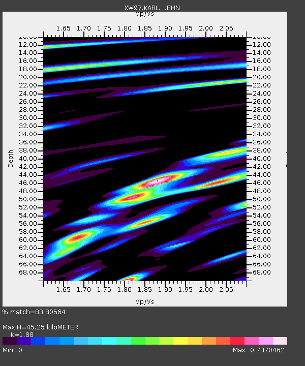
| Estimated Moho Depth: |
45.25 km |
| Estimated Crust Vp/Vs: |
1.88 |
| Assumed Crust Vp: |
6.491 km/s |
| Estimated Crust Vs: |
3.453 km/s |
| Estimated Crust Poisson's Ratio: |
0.30 |
|
| Radial Match: |
83.80564 % |
| Radial Bump: |
400 |
| Transverse Match: |
82.766136 % |
| Transverse Bump: |
400 |
| SOD ConfigId: |
20082 |
| Insert Time: |
2010-02-26 15:26:28.692 +0000 |
| GWidth: |
2.5 |
| Max Bumps: |
400 |
| Tol: |
0.001 |
|

Signal To Noise
| Channel | StoN | STA | LTA |
| XW:KARL: :BHN:20000710T10:05:50.793009Z | 23.042181 | 1.2332465E-6 | 5.352126E-8 |
| XW:KARL: :BHE:20000710T10:05:50.793009Z | 15.867334 | 1.2147948E-6 | 7.655947E-8 |
| XW:KARL: :BHZ:20000710T10:05:50.793009Z | 52.35605 | 4.5271217E-6 | 8.646798E-8 |
| Arrivals |
| Ps | 6.5 SECOND |
| PpPs | 19 SECOND |
| PsPs/PpSs | 25 SECOND |


