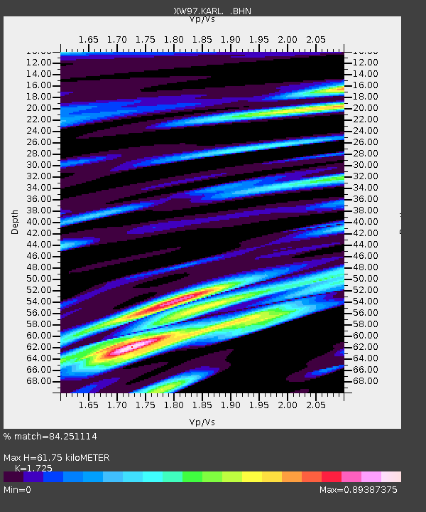
KARL XW.KARL - Earthquake Result Viewer
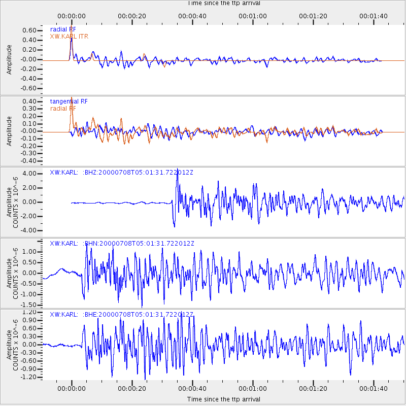
Earthquake location: Southern Sumatra, Indonesia
Earthquake latitude/longitude: -5.4/102.7
Earthquake time(UTC): 2000/07/08 (190) 04:52:55 GMT
Earthquake Depth: 33 km
Earthquake Magnitude: 5.7 MB, 5.7 MS, 5.9 MW, 5.8 MW
Earthquake Catalog/Contributor: WHDF/NEIC
Network: XW Tien Shan Continental Dynamics
Station: KARL XW.KARL
Lat/Lon: 41.47 N/77.31 E
Elevation: 3021 m
Distance: 52.1 deg
Az: 335.903 deg
Baz: 147.253 deg
Ray Param: 0.06690758
Estimated Moho Depth: 61.75 km
Estimated Crust Vp/Vs: 1.73
Assumed Crust Vp: 6.491 km/s
Estimated Crust Vs: 3.763 km/s
Estimated Crust Poisson's Ratio: 0.25
Radial Match: 84.251114 %
Radial Bump: 400
Transverse Match: 75.966446 %
Transverse Bump: 400
SOD ConfigId: 20082
Insert Time: 2010-02-26 15:26:32.134 +0000
GWidth: 2.5
Max Bumps: 400
Tol: 0.001

Signal To Noise

ChannelStoNSTALTA
XW:KARL: :BHN:20000708T05:01:31.722012Z2.718694.1828426E-71.5385508E-7
XW:KARL: :BHE:20000708T05:01:31.722012Z7.9919232.3939225E-72.9954276E-8
XW:KARL: :BHZ:20000708T05:01:31.722012Z20.4531861.279065E-66.253622E-8
Arrivals
Ps7.3 SECOND
PpPs24 SECOND
PsPs/PpSs32 SECOND