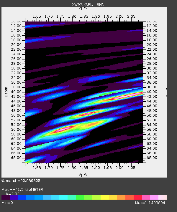
KARL XW.KARL - Earthquake Result Viewer
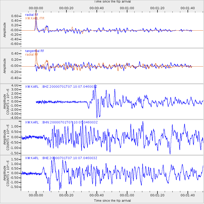
Earthquake location: Near S. Coast Of Honshu, Japan
Earthquake latitude/longitude: 34.2/139.1
Earthquake time(UTC): 2000/07/01 (183) 07:01:55 GMT
Earthquake Depth: 10 km
Earthquake Magnitude: 6.0 MB, 6.1 MS, 6.2 MW, 6.2 MW
Earthquake Catalog/Contributor: WHDF/NEIC
Network: XW Tien Shan Continental Dynamics
Station: KARL XW.KARL
Lat/Lon: 41.47 N/77.31 E
Elevation: 3021 m
Distance: 48.4 deg
Az: 297.719 deg
Baz: 77.456 deg
Ray Param: 0.06935999
Estimated Moho Depth: 41.5 km
Estimated Crust Vp/Vs: 2.03
Assumed Crust Vp: 6.491 km/s
Estimated Crust Vs: 3.197 km/s
Estimated Crust Poisson's Ratio: 0.34
Radial Match: 90.959305 %
Radial Bump: 400
Transverse Match: 78.6605 %
Transverse Bump: 400
SOD ConfigId: 20082
Insert Time: 2010-02-26 15:26:33.529 +0000
GWidth: 2.5
Max Bumps: 400
Tol: 0.001

Signal To Noise

ChannelStoNSTALTA
XW:KARL: :BHN:20000701T07:10:07.046003Z0.539673757.997765E-81.4819629E-7
XW:KARL: :BHE:20000701T07:10:07.046003Z1.41891371.89382E-71.3346971E-7
XW:KARL: :BHZ:20000701T07:10:07.046003Z3.6862994.793488E-71.3003523E-7
Arrivals
Ps6.9 SECOND
PpPs18 SECOND
PsPs/PpSs25 SECOND