You are here: Home > Network List > XW97 - Tien Shan Continental Dynamics Stations List
> Station KARL XW.KARL > Earthquake Result Viewer
KARL XW.KARL - Earthquake Result Viewer
| Earthquake location: |
Mariana Islands |
| Earthquake latitude/longitude: |
14.1/145.0 |
| Earthquake time(UTC): |
2000/06/21 (173) 16:25:06 GMT |
| Earthquake Depth: |
112 km |
| Earthquake Magnitude: |
5.7 MB, 6.0 MW, 5.9 MW |
| Earthquake Catalog/Contributor: |
WHDF/NEIC |
|
| Network: |
XW Tien Shan Continental Dynamics |
| Station: |
KARL XW.KARL |
| Lat/Lon: |
41.47 N/77.31 E |
| Elevation: |
3021 m |
|
| Distance: |
64.1 deg |
| Az: |
309.399 deg |
| Baz: |
93.909 deg |
| Ray Param: |
0.058846433 |
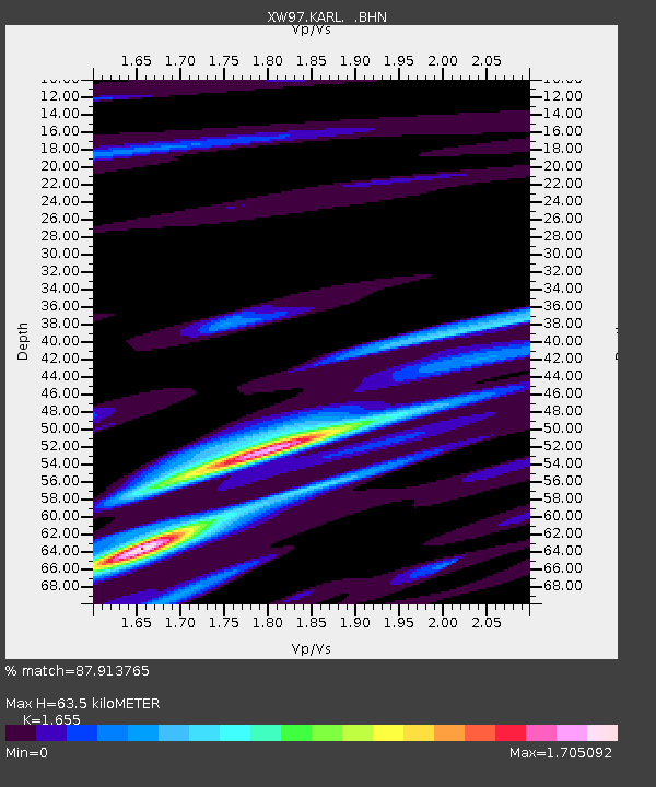
| Estimated Moho Depth: |
63.5 km |
| Estimated Crust Vp/Vs: |
1.65 |
| Assumed Crust Vp: |
6.491 km/s |
| Estimated Crust Vs: |
3.922 km/s |
| Estimated Crust Poisson's Ratio: |
0.21 |
|
| Radial Match: |
87.913765 % |
| Radial Bump: |
400 |
| Transverse Match: |
86.656944 % |
| Transverse Bump: |
400 |
| SOD ConfigId: |
20082 |
| Insert Time: |
2010-02-26 15:26:35.959 +0000 |
| GWidth: |
2.5 |
| Max Bumps: |
400 |
| Tol: |
0.001 |
|

Signal To Noise
| Channel | StoN | STA | LTA |
| XW:KARL: :BHN:20000621T16:34:57.649021Z | 0.99250686 | 3.646326E-8 | 3.6738545E-8 |
| XW:KARL: :BHE:20000621T16:34:57.649021Z | 1.998112 | 7.8827306E-8 | 3.9450896E-8 |
| XW:KARL: :BHZ:20000621T16:34:57.649021Z | 4.1871934 | 2.041872E-7 | 4.8764694E-8 |
| Arrivals |
| Ps | 6.7 SECOND |
| PpPs | 25 SECOND |
| PsPs/PpSs | 32 SECOND |


