You are here: Home > Network List > GE - GEOFON Stations List
> Station APE GEOFON/NOA Station Apirathos, Naxos, Greece > Earthquake Result Viewer
APE GEOFON/NOA Station Apirathos, Naxos, Greece - Earthquake Result Viewer
| Earthquake location: |
Lake Tanganyika Region |
| Earthquake latitude/longitude: |
-8.0/30.7 |
| Earthquake time(UTC): |
2000/10/02 (276) 02:25:31 GMT |
| Earthquake Depth: |
34 km |
| Earthquake Magnitude: |
6.1 MB, 6.7 MS, 6.5 MW, 6.2 ME |
| Earthquake Catalog/Contributor: |
WHDF/NEIC |
|
| Network: |
GE GEOFON |
| Station: |
APE GEOFON/NOA Station Apirathos, Naxos, Greece |
| Lat/Lon: |
37.07 N/25.53 E |
| Elevation: |
620 m |
|
| Distance: |
45.1 deg |
| Az: |
354.147 deg |
| Baz: |
172.746 deg |
| Ray Param: |
0.07144951 |
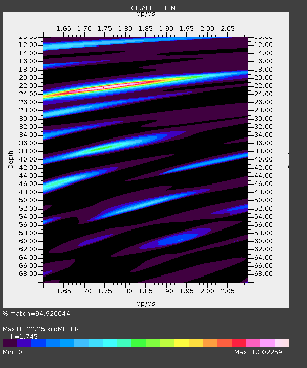
| Estimated Moho Depth: |
22.25 km |
| Estimated Crust Vp/Vs: |
1.75 |
| Assumed Crust Vp: |
5.738 km/s |
| Estimated Crust Vs: |
3.288 km/s |
| Estimated Crust Poisson's Ratio: |
0.26 |
|
| Radial Match: |
94.920044 % |
| Radial Bump: |
400 |
| Transverse Match: |
90.24989 % |
| Transverse Bump: |
400 |
| SOD ConfigId: |
3744 |
| Insert Time: |
2010-03-09 06:39:24.160 +0000 |
| GWidth: |
2.5 |
| Max Bumps: |
400 |
| Tol: |
0.001 |
|

Signal To Noise
| Channel | StoN | STA | LTA |
| GE:APE: :BHN:20001002T02:33:13.506014Z | 13.968735 | 2.0043606E-6 | 1.4348906E-7 |
| GE:APE: :BHE:20001002T02:33:13.506014Z | 2.0457025 | 3.814906E-7 | 1.8648392E-7 |
| GE:APE: :BHZ:20001002T02:33:13.506014Z | 12.432597 | 3.175286E-6 | 2.5540007E-7 |
| Arrivals |
| Ps | 3.0 SECOND |
| PpPs | 10 SECOND |
| PsPs/PpSs | 13 SECOND |


