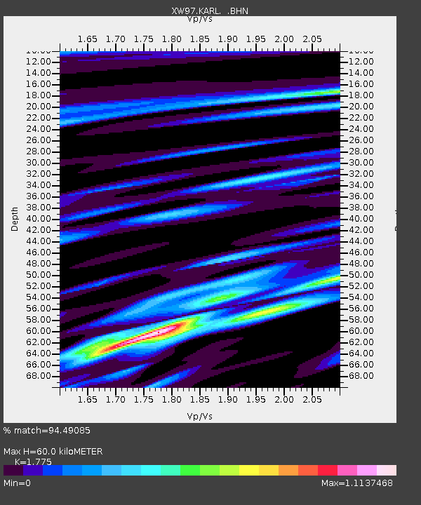
KARL XW.KARL - Earthquake Result Viewer

Earthquake location: South Indian Ocean
Earthquake latitude/longitude: -13.8/97.5
Earthquake time(UTC): 2000/06/18 (170) 14:44:13 GMT
Earthquake Depth: 10 km
Earthquake Magnitude: 6.8 MB, 7.8 MS, 7.8 MW, 7.6 MW
Earthquake Catalog/Contributor: WHDF/NEIC
Network: XW Tien Shan Continental Dynamics
Station: KARL XW.KARL
Lat/Lon: 41.47 N/77.31 E
Elevation: 3021 m
Distance: 58.1 deg
Az: 342.245 deg
Baz: 156.782 deg
Ray Param: 0.06308885
Estimated Moho Depth: 60.0 km
Estimated Crust Vp/Vs: 1.77
Assumed Crust Vp: 6.491 km/s
Estimated Crust Vs: 3.657 km/s
Estimated Crust Poisson's Ratio: 0.27
Radial Match: 94.49085 %
Radial Bump: 400
Transverse Match: 81.16362 %
Transverse Bump: 400
SOD ConfigId: 20082
Insert Time: 2010-02-26 15:26:40.674 +0000
GWidth: 2.5
Max Bumps: 400
Tol: 0.001

Signal To Noise

ChannelStoNSTALTA
XW:KARL: :BHN:20000618T14:53:35.450015Z9.5646626.954257E-77.270782E-8
XW:KARL: :BHE:20000618T14:53:35.450015Z6.32008172.086681E-73.301668E-8
XW:KARL: :BHZ:20000618T14:53:35.450015Z19.9626881.9639567E-69.838138E-8
Arrivals
Ps7.5 SECOND
PpPs24 SECOND
PsPs/PpSs32 SECOND