You are here: Home > Network List > GE - GEOFON Stations List
> Station APE GEOFON/NOA Station Apirathos, Naxos, Greece > Earthquake Result Viewer
APE GEOFON/NOA Station Apirathos, Naxos, Greece - Earthquake Result Viewer
| Earthquake location: |
Kodiak Island Region, Alaska |
| Earthquake latitude/longitude: |
57.1/-153.2 |
| Earthquake time(UTC): |
2001/01/10 (010) 16:02:44 GMT |
| Earthquake Depth: |
33 km |
| Earthquake Magnitude: |
6.2 MB, 6.8 MS, 7.1 MW, 6.8 ML |
| Earthquake Catalog/Contributor: |
WHDF/NEIC |
|
| Network: |
GE GEOFON |
| Station: |
APE GEOFON/NOA Station Apirathos, Naxos, Greece |
| Lat/Lon: |
37.07 N/25.53 E |
| Elevation: |
620 m |
|
| Distance: |
86.2 deg |
| Az: |
1.009 deg |
| Baz: |
359.311 deg |
| Ray Param: |
0.04417328 |
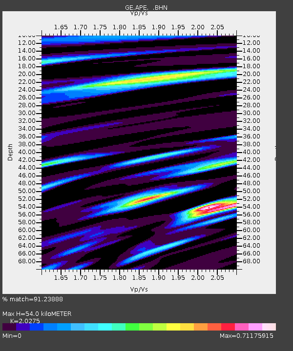
| Estimated Moho Depth: |
54.0 km |
| Estimated Crust Vp/Vs: |
2.03 |
| Assumed Crust Vp: |
5.738 km/s |
| Estimated Crust Vs: |
2.83 km/s |
| Estimated Crust Poisson's Ratio: |
0.34 |
|
| Radial Match: |
91.23888 % |
| Radial Bump: |
400 |
| Transverse Match: |
80.58127 % |
| Transverse Bump: |
400 |
| SOD ConfigId: |
3744 |
| Insert Time: |
2010-03-09 06:39:33.734 +0000 |
| GWidth: |
2.5 |
| Max Bumps: |
400 |
| Tol: |
0.001 |
|

Signal To Noise
| Channel | StoN | STA | LTA |
| GE:APE: :BHN:20010110T16:14:51.081013Z | 5.0571914 | 5.1021925E-7 | 1.0088984E-7 |
| GE:APE: :BHE:20010110T16:14:51.081013Z | 1.166273 | 1.2842568E-7 | 1.10116304E-7 |
| GE:APE: :BHZ:20010110T16:14:51.081013Z | 16.710186 | 1.6804609E-6 | 1.0056505E-7 |
| Arrivals |
| Ps | 9.8 SECOND |
| PpPs | 28 SECOND |
| PsPs/PpSs | 38 SECOND |


