You are here: Home > Network List > GE - GEOFON Stations List
> Station APE GEOFON/NOA Station Apirathos, Naxos, Greece > Earthquake Result Viewer
APE GEOFON/NOA Station Apirathos, Naxos, Greece - Earthquake Result Viewer
| Earthquake location: |
Kuril Islands |
| Earthquake latitude/longitude: |
44.2/148.5 |
| Earthquake time(UTC): |
2001/06/24 (175) 13:18:51 GMT |
| Earthquake Depth: |
33 km |
| Earthquake Magnitude: |
5.8 MB, 5.7 MS, 6.0 MW |
| Earthquake Catalog/Contributor: |
WHDF/NEIC |
|
| Network: |
GE GEOFON |
| Station: |
APE GEOFON/NOA Station Apirathos, Naxos, Greece |
| Lat/Lon: |
37.07 N/25.53 E |
| Elevation: |
620 m |
|
| Distance: |
84.0 deg |
| Az: |
317.576 deg |
| Baz: |
37.354 deg |
| Ray Param: |
0.045712784 |
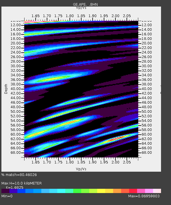
| Estimated Moho Depth: |
10.0 km |
| Estimated Crust Vp/Vs: |
1.68 |
| Assumed Crust Vp: |
5.738 km/s |
| Estimated Crust Vs: |
3.411 km/s |
| Estimated Crust Poisson's Ratio: |
0.23 |
|
| Radial Match: |
80.46026 % |
| Radial Bump: |
400 |
| Transverse Match: |
73.51271 % |
| Transverse Bump: |
400 |
| SOD ConfigId: |
4714 |
| Insert Time: |
2010-03-09 06:39:36.909 +0000 |
| GWidth: |
2.5 |
| Max Bumps: |
400 |
| Tol: |
0.001 |
|

Signal To Noise
| Channel | StoN | STA | LTA |
| GE:APE: :BHN:20010624T13:30:47.767007Z | 4.7853293 | 2.290083E-7 | 4.785633E-8 |
| GE:APE: :BHE:20010624T13:30:47.767007Z | 2.922545 | 1.6110288E-7 | 5.5124172E-8 |
| GE:APE: :BHZ:20010624T13:30:47.767007Z | 13.395076 | 1.0104573E-6 | 7.543498E-8 |
| Arrivals |
| Ps | 1.2 SECOND |
| PpPs | 4.6 SECOND |
| PsPs/PpSs | 5.8 SECOND |


